Sunday Evening

>> Sunday, December 31, 2006

Not a whole lot of time tonight, but I wanted to put up a few quick thoughts.

Rain moves on through tonight...maybe even a few rumbles of thunder. But, not a huge deal....I don't anticipate flooding or severe weather. Temps will continue to slowly rise overnight.

The first week of the new year will be a mild one. I anticipate each high temp tomorrow through next weekend to be above average. However, I still like the idea of colder air invading the eastern US between January 10th and 15th. And, at that point, I think this prolonged above averate temp spell will be over for a while. Will we get locked into a bonafide cold weather pattern? Not sure as of yet.

Happy New Year everyone! Let's all make this a great year together!

Read more...

When will winter return to the East??

>> Saturday, December 30, 2006

First off, I am feeling much better today. I have loaded up on vitamin B12 yesterday and today. I don't know if it is that or the virus just ran its course, but either way, I am much-improved. Not 100% yet, but getting closer....

As to the question in the title, I am continuing to get more confident that winter will indeed make a comeback over the eastern US next month. And, I continue to think we will see significant signs of that occurring in the January 10-15th time-frame. Here are a few of the reasons why....

  1. The NAO will trend toward neutral by mid-month after beginning the month on the positive side. In fact, I think the NAO could make a run at being negative by the time the second half of the month unfolds.
  2. The AO, which has been raging positive since the end of November, will take a big tumble around mid-January. The last time the AO took a crash like I am expecting was back in October. By the way, if you recall, Charlotte finished October almost 4 degrees below average in the temp department.
  3. A deep trough will likely dig into eastern Asia and Japan next weekend. Using the typical 6-10 day teleconnection there to the eastern US, that would again indicate a good chance for and eastern US trough right in the 10th-15th time-frame.
Now, will this be another transient shot of colder weather, or will it be a more sustainable pattern. Well, in my opinion, this hinges on two things. First of all, the dreaded southeast ridge. If you like cold and snow in the East, this thing has been brutal for the past couple of weeks, and it looks to hold fairly strongly on into January. But, there are signs this will break down around mid-month next month, and if that occurs...definitely a good thing for cold weather fans in the East.

Secondly, can we get any blocking established? I don't have a good answer on that one yet. But, my gut tells me that as we head through the second half of January, we will indeed see blocking set up that could keep us in a prolonged colder than average pattern. But, we shall see....

So, there ya have it. I do think a colder pattern will make a return to the eastern US by around mid-January. However, don't get me wrong....at least the first 7-9 days of the month will feature primarily above average temps around here. The potential pattern change is after that.

And, how about some December verification? Through yesterday, CLT was a +2.3 for December. My forecast was +0.5. The error there was an expected end of the month cool-down that simply didn't happen. My forecast, from back in mid-November, for January for CLT was a -2.0. For the moment, I will still ride with that, although the second half of the month will certainly have to be cold to overcome the warm start to the month for that to verify.

Read more...

Short Post

>> Friday, December 29, 2006

Short post tonight...I am a bit under the weather....I think I finally caught the stomach virus that the kids have had for the past several days. Not feeling my best by any means....

But, some quick thoughts.....

  • Sunday night into at least Monday morning looking quite wet around here.
  • Warmer than average weather will be the rule for much of next week.
  • I am liking more and more the idea of a major pattern change around mid-month January. Most of the teleconnection indices are heading that way. I am still hammering down a time-frame, but I still like the idea between the 10th and 15th as being the time when things really start to show signs of changing to a colder pattern for the East.
Time to wrap up the shift tonight. After a long day and this virus eating at me, the bed will feel good tonight....

See you on the television in Charlotte tomorrow evening!

Read more...

>> Thursday, December 28, 2006

I sincerely hope all of you had a great and happy Christmas. We all enjoyed a nice Christmas at our house. I guess the downside was that the kids took turns being sick through the holiday, but all in all, things went very well.

It is time to evaulate how things are going with our winter around here. Above average certainly fits the bill for our temps ever since the early-month cold snap. And, I think for the most part, the above average temps will continue for the next couple of weeks.

If you remember, in my winter forecast, I had the temp forecast in Charlotte for December slightly above average at +0.5 degrees. I feel I had the right idea, with some radical temp swings. But I had envisioned that we would be back in a colder pattern by the end of the month, and that simply won't happen. Right now, the departute from normal for CLT in December is running a bit above 2 degrees above average. We will probably finish somewhat close to 2 or 3 degrees above average for the month.

Now, I know it feels the times are getting desparate for lovers of snow and cold weather. However, take heart. Looking at the east Asia teleconnection, combined with some of the other teleconnection indices, I feel we will see a significant push of colder air around mid-January....probably between the 10th and the 15th. However, don't hold me to any details just yet....I am not completely ready to commit on a time-frame. But, the point of me saying this was to say to the fellow cold weather and snow lovers over the eastern U.S. "take a deep breath.....stay calm......and be patient. I think the pattern will start looking much better for the second half of January." However, between now and then, I think it is likely lights-out for any snow chances around here.

I will be the met for both the Charlotte and Triad markets Friday evening, so I will try to put some more thoughts on here sometime tomorrow evening. Have a good night!

Read more...

Merry Christmas!

>> Sunday, December 24, 2006

Luke 2:1-20

1
Now in those days a decree went out from Caesar Augustus, that a census be taken of all the inhabited earth.

2This was the first census taken while Quirinius was governor of Syria.

3And everyone was on his way to register for the census, each to his own city.

4Joseph also went up from Galilee, from the city of Nazareth, to Judea, to the city of David which is called Bethlehem, because he was of the house and family of David,

5in order to register along with Mary, who was engaged to him, and was with child.

6While they were there, the days were completed for her to give birth.

7And she gave birth to her firstborn son; and she wrapped Him in cloths, and laid Him in a manger, because there was no room for them in the inn.

8In the same region there were some shepherds staying out in the fields and keeping watch over their flock by night.

9And an angel of the Lord suddenly stood before them, and the glory of the Lord shone around them; and they were terribly frightened.

10But the angel said to them, "Do not be afraid; for behold, I bring you good news of great joy which will be for all the people;

11for today in the city of David there has been born for you a Savior, who is Christ the Lord.

12"This will be a sign for you: you will find a baby wrapped in cloths and lying in a manger."

13And suddenly there appeared with the angel a multitude of the heavenly host praising God and saying,
14"Glory to God in the highest,
And on earth peace among men with whom He is pleased."

15When the angels had gone away from them into heaven, the shepherds began saying to one another, "Let us go straight to Bethlehem then, and see this thing that has happened which the Lord has made known to us."

16So they came in a hurry and found their way to Mary and Joseph, and the baby as He lay in the manger.

17When they had seen this, they made known the statement which had been told them about this Child.

18And all who heard it wondered at the things which were told them by the shepherds.

19But Mary treasured all these things, pondering them in her heart.

20The shepherds went back, glorifying and praising God for all that they had heard and seen, just as had been told them.


John 3:16

For God so loved the world that He gave His only begotten Son, that whoever believes in Him should not perish but have everlasting life.


May you all have a safe and blessed Christmas!


Read more...

Christmas Eve Eve

>> Saturday, December 23, 2006

Wow....70 degrees in CLT today.....lower 70s across much of the area. That does not feel like December 23rd.

We will still be pretty warm for Christmas Eve with highs in hte low to mid 60s. However, a low will move across the northern Gulf tomorrow and then across the western Carolinas Christmas Day. That low will spread a lot of rain in here for Christmas with highs struggling to reach the lower 50s.

Behind that low, temps in the 850mb to 500mb level drop like a rock by Monday night. As those very cold temps aloft move overhead, we could squeeze out a few snow flurries in the Monday night-Tuesday morning time period. Should not be a big deal, but something neat to see if it happens. Now, a different story up in the mountains....some significant snows will likely occur between Monday night and Tuesday night. In fact, I think the favorable NW facing slopes could see at least a half a foot, and possibly more. Good news for the ski industry!

Temps will be close to average for much of the week next week from Christmas on. In fact, we will be below average on some occasions, such as lows Wednesday and Thursday morning, when 20s are likely.

I am still looking at the storm system for the end of next week. I still like the idea of this system really wrapping up nicely, but I don't have a good idea about the track yet. Probably rain for us, but stay tuned...

I will make another post sometime tomorrow. But, if you don't check in again before then, I want to be sure and wish you a merry Christmas! May you be filled with the warmth and peace of God's love...

Read more...

>> Friday, December 22, 2006

Not much time this morning, but I wanted to put up a quick post...

  • Old-fashioned rainy day today. Rain will taper off tonight. 1-2 inches seems likely, with a few spots seeing locally more. Due to dry ground conditions, most flooding issues should be confined to the mountains and foothills.
  • Dry and warm Saturday and Christmas Eve. Highs will be in the 60s.
  • Rain returns Christmas Day. I still am going with the idea of some sort of wedge being in place Christmas, and thus, I continue with a high temp in the 40s for Christmas with good rain chances.
  • As the upper level trough moves overhead Tuesday, we could squeeze out a few flurries. Not a big deal, but it would be neat to see. Up in the mountains, significant upslope snows could occur Monday night and Tuesday.
  • Wednesday and Thursday look quiet.
  • The next storm system should move through Friday or next weekend. Some models are hitting on the idea of a big-time amplification with that system. I am inclined to agree with them, but any details with that system are impossible right now.
Stay dry today. Some of my family is heading into town, and they will be with us through the Christmas holiday. So, posts might be a tad more infrequent. I will be back in the evening shift for Charlotte Saturday and Sunday. And, Sunday evening, I will be tracking Santa! Be sure and tune in!

Read more...

Thursday Morning Thoughts...

>> Thursday, December 21, 2006

Well, December 21st is upon us....the official start to Winter today. Also, today features the least amount of daylight time of the year...the amount of daylight will progressively increase from here on out.

Also, another thing to note about December 21st.....it is only 4 days until Christmas! Wow....

I took a walk with the kids yesterday evening. As I have mentioned before, we have a 3 1/2 year old, a nearly 2 year old, and a 7 week old. Well, Grace (the almost 2 year old) and Jayden (3 1/2 year old) absolutely love Santa...even seeing pictures of him. One of our neighbors has a Santa decoration on their mailbox, and on our walk, Grace and Jayden spotted the Santa. Well, Grace just had to give Santa a hug. Then she had to give Santa a kiss. Then she had to touch his feet. Then we had to look at his eyes, nose, and mouth. I thought it was very sweet. But, on the other hand, if the neighbors happened to look out the window right then, they would have seen me lifting a toddler up and down so she could hug the decoration.....good stuff.

As for the weather, look for intervals of mainly light rain today and tonight. However, the rain will likely become heavy at times tomorrow afternoon and night. I am expecting about 1-3 inches of rain before all is said and done Saturday morning. I still don't expect widespread flash flooding problems due to the recent dry weather. However, swollen stream and river beds are a definite possibility, so if you live in a flood-prone area, pay attention to that possibility.

Interesting developments with our Christmas storm system. The GFS continues with its general idea of a wedge holding in our area and the low going up near the Carolina coast. However, the 0z European model has come in with a much deeper, farther west solution. If the GFS is correct, we are probably looking at 40s with rain here in the Piedmont for Christmas. If the Euro is correct, we could push the lower 60s with rain for Christmas. I am still going with the GFS idea of a chilly rain arriving for Christmas Day. However, I will admit I am a bit nervous seeing the European model data. A lot of times, the trend with these types of lows is a westward one with time. So, that Euro solution could wind up being correct, and we could wind up much milder Christmas than what I have going in the forecast right now. We shall see...

I should also mention the GFS indicates the possibility of some flurries or snow showers behind the main low for Tuesday. However, let's figure out where the system will track before we look any deeper at that!

Everyone, have a great day today. Thanks for stopping by....

Read more...

Whew.....

>> Wednesday, December 20, 2006

I don't really feel like I have sat down since Sunday night. As I figured, Monday and Tuesday featured lots of activities for us, and we were on the go most of those days.

Today, I am holding down the midday shift for both Charlotte and the Triad markets. Due to a Presidential news conference News 14 carried, my normal schedule of getting weathercasts ready to go for both markets was delayed fairly significantly.....still playing catch-up as we speak.....busy day for sure.

A couple of forecast ideas though....

  • Friday, Friday night, and at least Saturday morning will be quite wet. I don't expect flooding, but certainly, a good, soaking rain.
  • Christmas Eve looks dry and relatively mild...meaning upper 50s to lower 60s for highs.
  • Gulf low pressure lifts up near the Carolina coast Christmas Day. This spreads a chilly rain in here for much of Christmas Day and Monday night. This system could produce some snow in the mountains. Outside of the mountains, while I think some sort of wedge will likely be in place, I think our airmass will likely be a tad too warm for anything wintry. But, I will keep a close eye on it, just in case.
Well, that's about all for now. My busy day continues, and I am out of time to post at the moment.

Thanks for stopping by, and come back!

Read more...

Frustrating Times...

>> Sunday, December 17, 2006

As a meteorologist, with the type of personality I have, it is very frustrating when I cannot get a handle on something having to do with the weather. I left work last night with a very unsatisfied feeling. For those of you that love the weather and have a passion for forecasting it, you likely understand what I am talking about. I understand that only God knows what will happen in the future, but normally, I at least have a good idea about the general forecast ideas for the next 2-3 weeks. Last night, I left work feeling fairly clueless outside of a change back to more seasonal temps by Wednesday.

But today, I feel I am getting a little better handle on where we are headed for the rest of the month. Here are some of the ideas I have as of now...

  1. The change back to December-like temps will occur, on schedule, by Wednesday.
  2. I still like the general forecast idea of seasonal temps (generally 50s for highs and 30s for lows) at least through Christmas, beginning Wednesday.
  3. The pattern is looking very unsettled beginning later Thursday and lasting until at least a couple of days after Christmas....meaning at least a couple of storm systems should roll through our area.
  4. The first system should move through Friday. We could see some wedging occur as this system moves in, but temps should be too warm for anything wintry.
  5. Another storm system will likely move through between December 25th and December 27th. Most models are in agreement with some sort of system rolling through around that time. However, trying to forecast a track for that second storm system is fruitless at this juncture. I bet we will see the models flip-flop several times on the eventual track of that storm system over the next 5-7 days.
  6. I still think the month finishes out without any further significantly above-average temps.
So, there ya have it. Today is my 'Friday'....my weekend is about to begin. So, I will try to post from time to time Monday and/or Tuesday. However, with these being my last off days before Christmas, there is a lot to be done in the East household.

Everyone have a great week, and I will post more when time allows....

Read more...

Saturday evening...

>> Saturday, December 16, 2006

Well, the 0z Canadian discussed below is an outlier amongst the computer models....most models just show a slow-moving cold front moving through our area late in the week. Granted, the GFS has occasionally shown some cold air damming signals, but taken literally it is too warm for anything but rain. So, at the moment, I am not overly concerned about wintry weather potential around here next week or weekend.

However, the models continue to really struggle trying to figure out this complex split-flow pattern. So, I don't think it is wise to definitively say anything will or won't happen over the eastern US between now and the end of the year.

But, I will stand by my statement that I think from next Wednesday on, most of the rest of December should be relatively close to average temp wise. And, we could see a decent shot of colder air a time or two between now and the new year. I think this "blowtorch", significantly above average weather pattern is about to come an end.

One of my favorite teleconnections is eastern Asia. Often times, the upper air pattern that is occurring in east Aisa now tends to generally occur over the eastern US about a week or so from now. And, using that teleconnection, I feel fairly confident that we will not see this very warm pattern return after it leaves next week, at least through the new year.

I wish I could add more specifics about any storm systems over the next two weeks, but at this point, I simply cannot. So, I say stay tuned.

Read more...

Ice???

The 0z Canadian model has come in with the solution below for next weekend....
That is a Gulf of Mexico low pressure area about to come up the East Coast with a well-defined cold air damming signal from the Northeast right down through the Carolinas. That set-up would threaten the Carolinas with some wintry weather, probably ice.

The 0z GFS and to some extent the 0z European models are at least somewhat on board with that general type of set-up.

Now, I certainly am not saying we are going to have an ice storm next weekend. But, I did want to discuss with you what a couple of models were showing for about one week from now.

The models have really been struggling in the medium range, so this general idea will probably change. However, it is certainly interesting to watch!

Read more...

Friday Evening Post

>> Friday, December 15, 2006

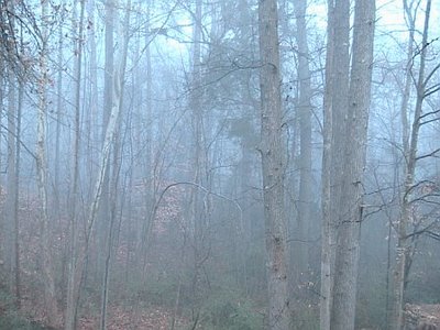
This is a shot taken of the woods out behind our house this morning. As you can see, the fog was quite dense. I know when I was driving to take Jayden (my oldest daughter) to preschool this morning, the visibility was less than a tenth of a mile....kinda felt like taking your life into your own hands when pulling out onto roads!

Speaking of preschool, today was the Birthday Party for Jesus for Jayden's class. All of the parents were invited, and it was neat to be there and see how things are going in school. My wife and I already seem to get very few details about how school is going from Jayden...I can only imagine how it will be as she gets older! The teachers do a great job with those kids, and it was a fun experience this morning.

As far as the weather is concerned, unseasonably warm weather will continue through Monday. But, as I have been mentioning for quite some time, we will transition back to a colder weather pattern later next week.

It seems the picture next week is becoming a bit clearer....however, in general, many of the computer models are still a convoluted mess. It appears a cold front will slip through, likely in dry fashion, Tuesday. Behind that front, highs look to mainly be in the 50s for the rest of the work week.

A 500mb low pressure area will eject out of the Southwest later next week. This type of scenario is one that computer models typically handle very poorly. The 0z run of the GFS tracked the 500mb low right over the Carolinas late next week. So, due to the very cold air aloft associated with the upper low, that run of the GFS featured a shot at some wintry precip for us as the low moved overhead.

However, subsequent GFS runs have shifted the track of the low farther north, and I think that farther north track is likely the correct one. The European model agrees with the farther north track as well. So, at this point, I am forecasting some showers later Thursday into Friday. There will likely be some wintry weather underneath that upper low, but at this point I think that will up over the Ohio Valley and not here.

Temps for Christmas should be relatively close to average for that time of year (50s for highs, 30s for lows). However, I like the idea of a big trough amplification around the 26th or 27th that could send a shot of cold air in here.

Long story short, I think this overly warm weather pattern ends next week, and the rest of the month will feature near or below average temps in general.

Read more...

Look North

>> Thursday, December 14, 2006

Due to the intense solar storm occurring, some places in NC just might catch a glimpse of the Northern Lights tonight.....get in the darkest spot you can and look generally northward. Let us know if you see anything!

Read more...

"The Weather Outside is.......Delightful."

Let me say this....I am a lover of cold weather and snow. So, mild weather in December is not what I would ideally draw up if I were in charge of the weather maps. And I know there are a lot of fellow cold and snow lovers out there as well. But, putting my love for snow and cold aside.....boy, the weather sure is nice out there. And, we will continue seeing unusually mild weather right through the weekend and into Monday and Tuesday of next week. In fact, I think we will see some lower 70s as we get into early next week. Pretty amazing stuff for December.

But, fellow cold weather fans....take heart. Changes are coming.

The models are still all over the place with the timing of this, but I am quite confident that we will transition back to a colder weather pattern by the end of the work week next week, and that colder weather pattern will likely hold for much of the rest of the month.

Here are my thoughts on some specific ideas with this transition....

  1. Cold front moves through around Wednesday...some showers associated with it.
  2. Colder air takes hold by Thursday and Friday, and it remains chilly deeper into the week of Christmas.
  3. A deep upper air low back in the Desert Southwest will provide us with many challenging forecasts from roughly the 23rd on.
  4. The potential exists for some sort of wintry weather situation to materialize by the end of the month in the Southeast US....but I can't be more specific at this point.
And, if you are keeping score at home, the December forecast from my initial Winter Forecast issued back on November 18 for Charlotte and the surrounding areas was a monthly temp averaging 0.5 degrees above normal. In fact, here is a paragraph from that forecast discussin December...

"I feel the "core" of this winter will occur during the months of January and February, and probably some of March as well. December will probably feature some wide temperature swings, but I think the month as a whole will average near or slightly above average for temperatures. My forecast for CLT for December temps is +0.5 degrees."

This month has certainly seen some wild temp swings....from record cold earlier in the month to near-record warmth through the mid-month period. As the month is unfolding, CLT might wind up being a bit below average temp-wise for the month, but I certainly think the December ideas laid out in the forecast held merit.

If you are having some sleep-troubles and would like to read the whole discussion from back on Nov. 18, you can do so going to the address below...

http://mattheweast.blogspot.com/2006/11/winter-ideas-for-charlotte-and.html

Read more...

CME headed our way...

>> Wednesday, December 13, 2006

http://www.space.com/scienceastronomy/061213_solar_storm.html

Read more...

Zzzzzzzzz

That is about how exciting the weather pattern is across our part of the country for the next 5 days or so. To be fair, the weather will be very nice with lots of sun and very pleasant afternoon temps. But, if you are looking for excitement, look elsewhere.....such as the Pacific Northwest, where a big-time storm system will slam that area over the next 36 hours or so.

Now, I do think our weather will get more interesting as we head through next week. The GFS is very bullish on developing a "wedge" Tuesday and Wednesday, which, if that verifies, would likely drop at least our high temps back near or below average.

But overall, I really do think we make a transition back to a colder weather pattern by the end of next week. I expect Christmas will definitely feature much more December-like temps, and there is a fairly strong possibility that the Christmas holiday will feature below average temps. And, there have been some indications of storminess around that time-frame as well, but let's not get carried away just yet.

Outside of the weather world, my family has been playing the "Let's Pass Around Some Annoying Little Cold" game for the past week or so. It seems yesterday and today have been myself and my oldest daughter's turn to have it. Nothing bad....no fever or anything serious. Just a messed-up nose and occasionally sore throat. Feels more like allergies than anything else.

And, goofy me had an older version of our current work schedule at home. So, I get in to work this morning anticipating doing midday weathers for the Triad and Charlotte markets only to see I was actually scheduled to be on the evening shift in the Triad. I am almost always vigilant about checking the current schedule....guess this one just "slipped past the goalie." My goof-up....

Read more...

Sunday Evening Thoughts...

>> Sunday, December 10, 2006

A rather benign weather pattern is settling in across much of the eastern U.S. The arctic airmass that moved in a few days ago continues to modify, and I think most lows will be close to 30 degrees tonight. Highs return to the 60s tomorrow.

I continue to think that the majority of the next 10 days to two weeks will be mild for our part of the country. However, toward the end of the month, there are some signs that a colder pattern for our area will try to return . Give me some more time to analyze that.

On another note, I was disappointed to see our Panthers lose again today. I have become a pretty big fan, and to see the team struggling like they are is disappointing. However, I still think if the team can get it together and win out, the playoffs are still a strong possibility. But, another loss is probably the nail in the coffin. Fans, don't give up.....keep pulling for the guys....

I am wrapping up another work week for me tonight. I will be off for a couple of days....back in the saddle again Wednesday here at News 14. In case you haven't thought about it, Christmas is only 2 weeks away. Still a lot of Christmas preps for the East's, so a lot of the off days will be spent associated with that.

At any rate, if something catches my attention, I will post about over the next couple of days. Otherwise, see you Wednesday!

Read more...

Bitterly Cold Tonight

>> Friday, December 08, 2006

Wow. Today was the coldest day we have had in quite some time with highs only in the 30s. And get ready, it will be dangerously cold tonight. Look for teens across the entire News 14 Carolina viewing area tonight. And, I really would not be shocked is some spots made a run at the upper single digits tonight. Record lows will likely be set in most places tonight.

Tonight will be the coldest night of this arctic outbreak, but it will take a few days to significantly warm our overnight lows. In fact, I don't think we see a low warmer than the 20s until Tuesday morning, at the earliest.

Still looks like a wedge will set up Tuesday and Tuesday night as our next storm system is taking shape off to our west. But, still looks to warm for anything wintry as the precip arrives. I expect showers Wednesday before the system departs Wednesday night.

The computer models have been flip-flopping on whether or not a Gulf of Mexico low pressure area will develop late in the week. If it were to develop, we would see additional rain chances by Friday or Saturday. However, most of the 12z guidance has come into agreement that the upper trough will remain progressive, thus no cut-off upper low and no Gulf of Mexico surface low. I am buying the no-low scenario right now and keeping the end of the week forecast dry.

Gazing deeper into the crystal ball, I still think the weather around here will be on the mild side next week and likely the week after as well. By mild, I am talking about primarily above average high and low temps. Now, we are not talking about record-breaking warmth, but I certainly see no brutal shots of cold air for a couple of weeks after our current shots leaves.

By early January, and possibly as early as Christmas, I think the pattern begins to revert back to a colder one for the eastern U.S. But until then, I think any outbreaks of true arctic air will be confined to the western half of the country.

Read more...

Wow...

We are definitely in the grips of an arctic airmass today. Lows this morning were in the teens across much of the region. Up in the mountains, it was incredibly cold. Just before midnight last night, I saw the wind chill at Mt. Mitchell was close to an incredible -50 degrees! Looks like Grandfather Mountain had a low around 0 at the Nature Museum.

We will likely not get out of the 30s in most places today, and then tonight, we will see lows just as cold, if not a little colder, than what we saw this morning. New record lows will likely be set in many spots.

Every bundle up. Remember those pets.

I will be evening meteorologist in the Triad market today and tonight. Let's hope for a smoother night tonight compared to all of the technical issues of last night!

Read more...

Brrrr

>> Thursday, December 07, 2006

Thought I would share this with you....

Currently (just after 9pm), the temperature is 4 with a wind chill of -14 at the Nature Museum at Grandfather Mountain. I would imagine the summit is close to sub-zero!

Read more...

Technical Issues

Here at News 14 Carolina, we have had our share of technical issues this evening. We have been forced to go to back-up tape on a couple of occasions due to the HAL 9000 (the bohemoth that makes the whole thing go) acting up and not working properly. So, that is why you may have noticed some dated wording or weather material. At any rate, hopefully things get straigthened out soon....

On the weather front......brrrrr. Man, just opened the door outside of the studio here, and wow....I would say the arctic airmass is taking hold. Very blustery conditions out there now, and the mercury will continue to drop down toward the lower 20s tonight.

I still think most spots will remain in the upper 30s for highs tomorrow, then look out tomorrow night....widespread teens for lows are on the way. I have a temp forecast of 16 going for the Triad now in my overnight forecast package, and I believe Jeff has gone with 13 for the Charlotte market. Both would be records.

This is serious cold. Do not leave pets outdoors. Wrap up those pipes. And it seems like every time we get one of these cold weather snaps, unfortunately someone gets seriously injured or killed from carbon monoxide poisoning from trying to heat their home with something it is not designed for, such as charcoal. Please be careful.

Bundle up, stay warm. Warmer times are ahead. We should hit the lower 60s for highs early next week.

By the way, I get the feeling we will see a cold air damming situation set up as our mid-week storm system approaches. But, it looks too warm for anything wintry.

Read more...

Blowing Rock

Looks like some snow falling right now up in Blowing Rock. Check out the webcam below....obviously, this is time-sensitive....

http://www.highcountrywebcams.com/webcameras_BlowingRockRoad.htm

Actually, a number of cameras are showing the snow nicely right now....

http://www.highcountrywebcams.com/

Look at the cameras about Boone and Blowing Rock....

Read more...

Wednesday Afternoon Post

>> Wednesday, December 06, 2006

First of all, thanks to all of you for checking back and keeping up with the blog. I am sorry for the lack of posts the past couple of days....lots of family things going on, such as my oldest daughter's school Christmas show last night.

At any rate, I am back in the saddle today, holding down the midday fort for both Charlotte and the Triad.

No late-week storm system to bring us any precipitation is coming, but a big-time blast of arctic air is heading our way. This arctic shot will only last about 48 hours, but let me tell you....this will be some of the coldest air you see this time of year.

The arctic air really plunges in here beginning late tomorrow afternoon. I think by Friday morning, temps will be near 20 degrees, and I think many of us will stay in the 30s all day Friday. A very cold night is on the way Friday night with lows by Saturday morning likely in the teens. In fact, as I am typing this I see the new 12z GFS MOS data has come in with a low of 14 Saturday morning....yikes! We could very challenge the record low of 16 Saturday morning set back in 1917.

Gazing into the crystal ball, I am sticingk with the idea of generally warmer weather next week and probably much of the week after. But, I also still think things are probably aligning for a return to colder weather around here toward the end of the month or early January. I have not gotten a good feel for when I think this will happen....give me more time on that one.

Read more...

Saturday Evening Tidbits...

>> Saturday, December 02, 2006

Some quick evening notes here....

  • Showers push in to roughly the eastern half of the viewing area Sunday afternoon and evening....but the rain should leave before the atmosphere cools enough for anything wintry.
  • The upcoming week will be cold....below average for highs and lows. I still think low to mid 20s Tuesday morning.
  • The models can still not figure out how to handle the end of the week possibilities. Today's 0z GFS kept the energy more bundled, and thus, a more impressive late-week system. Other runs shear the energy out and nothing impressive develops. We shall see...
  • Had to switch mental gears today...after anchoring the evening weather shift for the Triad Wednesday through Friday, I am back in the Charlotte market today and tomorrow.
  • Can we please have some sort of college football playoff system. I don't want to hear the excuses....I am tired of having to debate every year who should play for a championship. Every other level of football has playoffs....why can't Division I football???? No, we have to have another year of debating who should play Ohio State......Florida or Michigan??? (assuming Florida holds on to win the SEC champ. game...although it is a dog fight right now)
End of rant.....have a great night!

Read more...

The week ahead....

>> Friday, December 01, 2006

Cold.....that about sums up next week. I think every day from Sunday through at least Friday will likely feature below average high and low temperatures. Look for many highs in the 40s and lows in the 20s next week.

We have two potential storm systems to deal with. The first one is a coastal area of low pressure that will form later Sunday and Sunday night just off of the Carolina coast. I think some showers will be possible over the eastern parts of both the Charlotte and Triad News 14 markets Sunday afternoon and night. And, while it is a close call, I think the rain leaves just prior to the deeper cold air arriving Sunday night. So, at this point, I don't think we have any wintry weather issues with that system. But it is fairly close, and we will watch it.

The second potential storm system is toward the end of the work week. However, that is about the extent of that I can tell you about that system. There are players on the field for a system to posssibly form Thursday or Friday, but whether or not those players come together properly or not remain to be seen. So, stay tuned on that one.

Also, if you remember (and you can read the whole thing by looking in the archives on the right), my forecast for December was for Charlotte to average 0.5 degrees above normal for the month. I still think that forecast is in OK shape. While we will see well below average temps through next week, I think the mid-month period sees a nice warm-up before possibly cooling down again toward Christmas. So, the forecast for December still looks OK right now.

Read more...

Impressive dewpoint drops....

The dewpoint at Greensbobo dropped 22 degrees in 2 hours this afternoon (from 62 to 40)....impressive stuff. Charlotte has seen a 24 degree dewpoint drop in 3 hours. Can you tell a cold front has moved through???

Read more...

Cold front sweeping through

The severe weather threat is over for our area. Thankfully, it never really got going. The cold front is moving through western parts of the area right now, and it will sweep rather quickly eastward. It is quite warm out there as I am typing this with temps running in the low to mid 70s.

The wind shift with the cold front is lagging a bit back to the west. So, we really won't see any rapid temperature drops until late afternoon and especially early evening.

I am just diving into all of the model data for the weekend and next week. WIll post more a bit later on....

Read more...

Watching the radar....

Watching to see if any active storms try to develop today. So far, all is quiet. The window of opportunity for any active storms would be later this morning into early afternoon. Again, so far, so good.

Read more...

Thursday Evening Post

>> Thursday, November 30, 2006

I am amazed watching the big storm system wrap up over the Lower Mississippi Valley. I simply love the weather, and watching a storm system like that take shape is a thing of beauty to me.

Tremendous snow totals are going to occur with this storm system. I think a strip os 12-20" snows will occur from eastern Oklahoma up through Illinois. Blizzard conditions will likely develop in the areas seeing the heavy snows, and travel will become impossible in those areas.

Around here, we are closely watching the potential for some severe weather as the cold front races through here tomorrow. It appears the window of opportunity for severe weather will be from about 7am until 2pm tomorrow. Damaging winds will be the primary severe weather threat.

There will not be much instability for this system to work with, but the dynamics are impressive. We all remember what happened with out last system that rolled through similar to this, so we will monitor it closely.

I think it is almost time to give up on our coastal system Sunday into Monday. It just looks fairly doubtful right now that the low will track close enough to the coast to give us precip. However, it is still close, and I will not completely write if off yet.

Our next storm system looks to roll in around next Thursday. It seems the GFS has indicated this storm system rolling through on a majority of its runs over the past couple of days, and the 0z European model jumped on board as well. I think chances are we will indeed see a system roll through during that time-period, but any specifics are impossible to forecast right now. However, I do think it holds some interesting possibilities around here, so stay tuned....

Read more...

MNF Snow

>> Monday, November 27, 2006

How about that snowy football game on Monday Night Football. Pretty neat to see, and not an everyday happening in Seattle.

There are some interesting forecast aspects around here over the next 15 days....if time allows, I will delve into some of that tomorrow. If not then, then certainly a full post will come online Wednesday.

Read more...

Sunday Morning Tidbits....

>> Sunday, November 26, 2006

  • More great weather today. Get out and enjoy, and be safe if you are travelling.
  • Some of the latest modelling has backed off a bit on the amount of cold air for late this week. At this point, I will stay the course and continue with highs in the 40s and lows in the 20s for Saturday and Sunday.
  • The models are struggling to handle how the end of the week upper trough will set-up, so any guess as to a possible surface system have to remain on hold for now.

Everyone have a great day. God bless....

Read more...

Good morning!

>> Saturday, November 25, 2006

It is fairly chilly out there as I am typing this this morning. Many locations had lows well down into the 30s. However, we will see highs close to 70 degrees today and tomorrow, so get out and enjoy.

If you have travel plans today or tomorrow, no real weather problems to worry about over the eastern U.S. However, another strong storm system will plow into the Pacific northwest tonight and tomorrow, and if your travel plans take you to that part of the country, you certainly could run into some delays there.

The big weather story this week will be a brutal surge of arctic air spreading across the country. That arctic air will arrive here Thursday night and Friday.

It is interesting to note that there have been some indications from time to time that another coastal low pressure area will try to develop around Friday. And why not?....each of the past couple of big troughs have managed to produce coastal low pressure areas. But I will admit that there are not as many model clues pointing to that scenario as there was the last time around. But, there is a difference with this weekend's possible coastal storm.....genuine arctic air will be in place across the eastern U.S.

So, while the jury is still out on whether another coastal system will form the end of this week, if it does form, it would likely produce primarily wintry weather over the Eastern Seaboard. The GFS has gone back and forth as to whether or not to develop a coastal low. The 6z run that just rolled in does indeed develop one. Look at the image below...


If that solution were correct, that would be snow falling Friday night in much of the Carolinas.

So, what to make of this....Well, it is simply too early for me to make a call. I do think there is a chance that this coastal low will develop, but at this point, it is just that....a chance. We shall see.

One thing is a near-certainty....much colder air will flow in here Friday and next weekend. I think 40s at best for highs with lows well down into the 20s. And, if we can get a night next weekend with a clear sky and light winds, I think some spots could possibly dip into the teens! Brrr....

Read more...

Happy Thanksgiving!

>> Thursday, November 23, 2006

I am covering all 3 markets for the midday shift today, so not much time to post. However, a couple of quick notes.

  • Clearing has taken place and beautiful weather is taking hold.
  • Sunshine with milder temps the rule through the weekend....probably some 70 degree high temps by Sunday or Monday.
  • Mild and docile weather continues into mid-week next week.
  • Cold front moves through next Thursday with some showers associated with it.
  • Big blast of cold air moves in by next Friday and next weekend. That shot of cold air will probably deliver the coldest low temperatures so far this season sometime NEXT weekend.
Everyone have a great Thanksgiving. Enjoy time with your family. And let's all be thankful for all of the blessing in our lives. God bless....

Read more...

Lots of sleet and snow reports...

>> Tuesday, November 21, 2006

Lots of sleet and snow reports are coming in from around our viewing area. It seems like every county that has seen the precip begin has seen at least a brief period of a mix of sleet and snow with the rain. This wintry mix will likely continue through much of the afternoon before the upper levels of the atmosphere warm up some tonight. Surface temps remain above freezing, so no accumulations or travel problems are expected, outside of wet roads. For those of us who love winter weather, enjoy today....I know I am!

Read more...

Wintry Morning

Amazing stuff off to our south and east this morning. Charleston, SC has actually had thundersnow, a pretty rare in its own right. But it is certainly quite a rarity in Charleston. This is apparently the earliest recorded snowfall in Charleston as well. Snow has also been reported in Fayetteville, NC. Temps all across the upper SC coast and lower NC coast are in the 30s with howling winds out of the north and northeast. Wind gusts are over 40mph.

Around the Piedmont, precip is spreading in from the east. As the precip begins this morning into early this afternoon, we will probably see some sleet or snow mixing in with light rain for a while before the atmosphere warms a bit by late afternoon. No wintry precip accumulations are expected around our area, but it sure is a wintry day. I think we will struggle to get out of the 30s in many spots, and winds will be brisk out of the north sustained at 10-25mph. Bundle up!

Read more...

Flakes in the air...

>> Monday, November 20, 2006

Asheville and Jefferson have reports some light snow at times this morning.

As the day progresses, I really think we will have a difficult time making it out of the 40s here in the Piedmont. Also, some light rain will occur from time to time, and I would not at all be surprised to see some snowflakes mix in at times. No big deal, but something neat if you do see it!

Read more...

Monday Morning Update

Models are coming into better agreement in the handling of the big upper air low this week. In short, it is looking pretty wet in the Tuesday through Thursday time frame for the Carolinas. Obviously, lots of folks will be travelling this week, and certainly there looks to be a lot of rain to deal with in the mid-week time period in the Carolinas.

This developing storm will batter coastal areas of the Carolinas with a few days of onshore flow, high surf, and lots and lots of rain. Beach erosion and flooding will likely be a problem.

It is also interesting to note that the past couple of runs of the GFS have indicated the chance that the precip begins as a period of snow and/or sleet down in South Carolina Tuesday morning. The NAM sounding are warmer, indicating all rain. But, I certainly would not be shocked if some of our friends in South Carolina saw a brief mix tomorrow morning before warmer air takes hold from the coast. Interesting to see this coming to fruition....if you scroll below to the post from last Monday, you can see I was discussing the European solution for this time period...it was indicating some wintry weather chances back then. Certainly an odd weather pattern.

Directly below this post is my Winter Outlook. Take a look and feel free to comment.

Read more...

Winter Ideas for Charlotte and the Surrounding Areas

>> Saturday, November 18, 2006

A couple of primary factors have gone into my winter ideas for this year. The first of which is the El Nino that is occurring this winter.

I firmly believe this will be a winter where the El Nino is at its strongest in early winter with a steady weakening of the El Nino as we progress to late winter. I think most of the winter will be spent in the "weak" El Nino category, with only a very brief time, if any at all, spend in the "moderate" category.

Another fascet of this year's El Nino is the matter of where the above-normal temperatures will be located in the Pacific. Here is the current (as of 11/18/06, as I am composing this outlook) sea surface temperature anomoly.


The shades of green, orange, yellow, and red are the above-average sea surface temperatures. Right now, the warmest surface water temps in the Pacific are rather close to the South American coast. However, if you look at the water temps at depth through the Pacific, and not just at the surface, the water temps are cooling beneath that very warm water at the surface in the eastern Pacific. So, I feel we will probably see that warm surface water in the eastern Pacific cool with time over the next couple of months. Again, looking at the water temps at depth, the temperatures beneath the surface are warming between about 140W and 180W, and I think as winter progresses the central Pacific will become the "dominant" area of warmer waters.

So, what does that mean? Generally speaking, in El Nino winters where the warmest waters are located just off of the South American coast, our area tends to have a milder than average winter due to a strong Pacific jet racing across the U.S. In El Nino winters where the warmest waters are located out in the central Pacific, the Pacific jet is still there, but it is much more favorable for shots of cold air to make it down into the eastern U.S. Keep that in mind.

Another fascet I feel is critical to our winter outlook is the NAO. That is the North Atlantic Oscillation, and it is a comparison of the barometric pressures between the subpolar low and the Azores high. I will just leave the description at that...if you have any questions about the NAO, I can get into it more deeply. At any rate, back to the forecast....

Since late summer, the NAO has generally been in the negative category. See the chart below.


Negative NAO's typically are favorable for colder and more snowy weather patterns during the winter months over the eastern U.S. I see no substantial reason for the NAO to switch around to a primarily positive phase through the winter, so I think much of the winter should be spent with a neutral to negative NAO, especially toward January and February.

There are some obviously plenty of other factors involved in my forecast that I won't bore you with in this space right now, but I have highlighted two of the factors that I feel will be very important this winter.

So, with that said, here is my actual forecast for this winter for the Piedmont of North Carolina. I feel the "core" of this winter will occur during the months of January and February, and probably some of March as well. December will probably feature some wide temperature swings, but I think the month as a whole will average near or slightly above average for temperatures. My forecast for CLT for December temps is +0.5 degrees.

I have gone back and forth with which month I think will be the coldest of the winter between January and February. For the forecast, I have decided on February. I think both months will have continued swings in temperatures, but overall, I think both months will be below average as the El Nino relaxes somewhat. So, my temp forecast for January is -1.5 degrees and February is -2.0 degrees.

As for precipitation, I think this will be a winter that features a good amount of southern branch storm systems rolling through the eastern U.S. I think the chances are good that the Charlotte area will see above average snowfall for the season. In fact, I expect the region to see several ice and/or snow threats as winter unfolds, especially during the months of January and February.

So, here is the recap.

Monthly temperature deviation from average:

December: +0.5
January: -1.5
February: -2.0

Read more...

North Carolina Tornadoes

>> Thursday, November 16, 2006

The NWS has finished some storn surveys around the area. Check out the link below:

http://kamala.cod.edu/offs/KGSP/0611162307.nous42.html

Looks like a few places in Gaston, Lincoln, and Iredell counties saw tornadoes last night.

Early next week continues to look "interesting." I will try to post more as time allows. Also, I will post my brief forecast for the upcoming winter for Charlotte sometime over the next week or so.

Terrible situation over in eastern North Carolina in the Riegelwood area. My prayers are with those folks. Read some preliminary information from the WIlmington, NC NWS at the link below...

http://kamala.cod.edu/offs/KILM/0611162348.nous42.html

Read more...

Storm Recap

Well, severe weather raked through the viewing area last night. Wind damage was reported in several counties, and some power outages have occurred. In fact, my oldest daughter has had school cancelled today due to power being out at her school.

It looks like areas a little west of Charlotte saw the worst of the damage in the Charlotte News 14 Carolina viewing area. Locations in Gaston and Lincoln counties reported wind damage. Tornado warnings were even issued for Yadkin and Guilford counties in the Triad viewing area.

I have always been fascinated watching thunderstorms roll through. I was afraid of night-time thunderstorms as a child, but that fear turned to respect and awe as I grew older. Being a broadcast meteorologist, you hardly ever get to actually watch storms as they move through. You are always on the air during those times, trying to keep folks safe as severe weather and storms are occurring. Don't get me wrong, I love severe weather coverage, and that is by far the most important part of our job. But, I will say it was a bit of a treat for me last night. As the line of storms rolled through our area, it was nice to be able to just sit and watch the beauty of night-time thunderstorms.

Read more...

Tornado Watch

>> Wednesday, November 15, 2006

The atmosphere around our viewing area has rapidly destabilized as we have gone through the past couple of hours. At the Gastonia airport, the temperature jumped from 60 to 67 degrees and the dewpoint jumped from 53 to 62 degrees in 1 hour's time!

A tornado watch is in effect for Cleveland, Gaston, Mecklenburg, Union, Cabarrus, and York counties. That watch is officially set to expire at 5am Thursday morning.

Look for a strong line of storms to blow through the area over the next 3 to 4 hours. Damaging winds are a distinct possibility, and a couple of isolated tornadoes will be possible as well. For those of you that are meteorologically-inclined, this is a situation where we have tremendous amounts of shear involved, so LEWPS and bow echos will be likely from time to time.

Stay weather-alert throughhout the night tonight. Jeff will continue to have continuing information for you on News 14 Carolina.

Read more...

Wintry Weather??

>> Monday, November 13, 2006

I am continuing on my leave this week. Again, many thanks to all of the good folks at News 14 Carolina for covering for me and pulling some extra shifts. My family and I greatly appreciate it!

Some interesting happenings in the weather ahead. First of all, a dynamic storm system wraps up over the Lower Mississippi Valley late Wednesday and lifts to the Great Lakes Thursday. The dynamics with this storm system will be very supportive of severe weather Wednesday in parts of Louisiana, Mississippi, Alabama, the Florida panhandle, and probably parts of Tennessee, Kentucky, and Georgia. The thermodynamics are a bit of a question mark, meaning the depth and quality of available instability remains to be seen. However, I think parts of that region are in for a healthy round of thunderstorms with lots of wind and probably some tornadoes.

As that system rolls through here, we will see rain and probably some storms. Some of our storms could even be strong to severe in the Wednesday night-Thursday morning time-frame. Keep it tuned to News 14 Carolina for all of the latest weather information.

Behind that storm system, chillier weather moves in for Thursday and Friday. I think flurries will fly Thursday up in the North Carolina mountains, and I think some mountain locations could see a bit of accumulating snow. Our weekend weather looks rather benign.

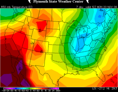
Interesting model developments for next Monday and Tuesday. For several runs now, some models have been developing a closed 500mb low somewhere near the Carolinas. From time to time the GFS has had this scenario, and now the 12z European is on board. Below is the 850mb relative humidity then the 850mb temperature charts for 7am Monday morning.

It sure looks like precipitation is falling around the Carolinas, and across parts of the area, the airmass is marginally cold enough to support something of the wintry variety. Looking from the European model site (the data I can view beyond Day 7 on the European model is limited), the 500mb low closes off and is sitting right over the Carolinas Tuesday morning. This would indicate very cold air aloft. So, what does this mean???

Well, first off, the chances of this exact solution verifying are slim. And, even in this exact scenario, the lower levels of the atmosphere outside of the mountains and foothills are likely too warm for snow. But, it sure is interesting, and this appears to be our first little winter weather potential of the season to watch. Again, this is probably nothing major at all, but it peaks my interest.

I also should mention that next Monday and Tuesday will likely be downright cold for November. I think 40s for highs are a good possibility, and it could wind up being lower 40s at best on one or both days. Stay tuned!

Read more...

Wednesday November 8, 2006

>> Wednesday, November 08, 2006

I wanted to take a second to check in. Thanks for the congrats below...I appreciate it. We are all still doing very well. Just got my oldest daughter off to pre-school this morning. Our nearly 2 year old and the newborn are helping clean up the house a bit this morning. Three kids under 4 years old....we are tremendously blessed, it is a lot of fun, and there is never a dull moment!

On to other matters, the weather is not just my job, it is my hobby as well. I am a weather nut, and I just enjoy everything about weather and the forecasting of it. So, while I am not making specific forecasts for on-air during my time off, I can't help but keep track of things and the general trends that lie ahead.

A decent shot of colder air wil arrive later this weekend behind a cold front that swings through Saturday. Look for some showers and possibly a storm or two as the front moves through Saturday. Sunday will be chillier with highs probably not making it out of the 50s.

The models are still all over the place with the details for next week, but in general, look for a storm system to move through mid-week with a big plunge of cold air surging in behind that storm system. Wednesday through Friday could wind up being pretty wet around here with occasional rain and maybe some storms. That system could provide some severe weather for the Lower Mississippi Valley and the Deep South. But by next weekend (18th and 19th), I think we will see a big blast of cold air in place around here and for most of the nation east of the Rockies.

And just for giggles, the GFS has occasionally been indicating an east coast storm system sometime Thanksgiving week. Obviously this is out in fantasy-land on the model, but it was indicating some snow for the New England states on the runs that showed that storm system. Again, nothing to get excited about yet, but a sure sign that we are getting close to the winter season around here!

Everyone have a great day, and I will try to post from time to time.

Read more...

>> Wednesday, November 01, 2006

We are very thankful and happy to announce that our third daughter was born Monday morning at 10:29am. Mother and baby are doing great, and we are just getting settled in to being at home as a family of 5 now!

I will be taking some time off over the next few weeks to spend time with my family. I will probably post on here from time to time, but posts will definitely be sporadic.

I want to take a second to thank everyone at work for taking on the extra work-load during the time that I will be out. I know it is a pain in the rear end for them, and I want them to know that my family and I are extremely appreciative. You guys are the best!

Anyway, everyone have a great week. Colder air arrives for Friday and this weekend, so enjoy the wamrth of today if you don't like the colder temps!

Read more...

Here comes the rain...

>> Friday, October 27, 2006

Showers are with us this morning, but the rain will become widespread this afternoon and continue through a good deal of tonight. Most rainfall amounts should be between 1 and 2 inches, but some spots could locally approach 3 inches. I don't think flash flooding will become a major issue, but some swollen creek and stream beds are likely.

The rain will exit by about daybreak Saturday, and a nice weekend is on the way. Sunshine builds in by tomorrow afternoon and will last through Sunday as well. Highs will be in the low to mis 60s. It will be rather breezy tomorrow with winds gusting out of the northwest to 25mph or so at times. Up in the mountains, wind gusts to 50mph or greater are possible tomorrow.

Halloween still looks nice with highs in the lower 70s and trick-or-treating temps in the 50s.

Our next cold front will move through about Thursday, and I still don't think the models have a good handle on the amount of cold air coming behind that front. I have gone colder with my high and low temperatures for the end of the week than numerical guidance indicates in anticipation that the models are not grasping the depth and strength of next week's cold shot. We shall see....

My family continues to battle some minor illness issues. My biggest problem is a sore throat, which makes talking tough at times....good for my profession, huh? So far though, it has not been a huge deal thankfully. For whatever reason, the illness has really messed up our youngest daughter's sleeping at night. She was wide awake and stunbling around with me at 2:00 this morning as I am trying to shake off the night's sleep and get moving. Anyway....

Everyone have a great day. Stay dry and warm!

Read more...

Good Morning!

>> Thursday, October 26, 2006

Back in the early AM seat today for the Charlotte market....will do the same tomorrow. I am really struggling with fatigue this morning. Both of our children are battling some sort of cough, runny-nose thing...the worst symptom they have is a lot of coughing at night. Bless her heart...our youngest just could not stop coughing last night. I might have gotten an hour of sleep, and poor thing, when I left, I don't think she or my wife had gotten much more. So, hopefully some serious nap time coming this afternoon!

At any rate, lots of clouds today, then rain arrives late tonight through tomorrow morning. Tomorrow will be a rainy, chilly, raw kind of day with highs struggling to reach the low to mid 50s. The rain will continue into tomorrow night, and I think most of us will see between 1 and 3 inches of rain before it ends early Saturday morning. So, another soaker on the way.

The weekend will be dry, and the dry weather looks to extend right into the first of next work week as well. For Halloween, lots of sun appears on the way with highs in the upper 60s. For the trick-or-treaters Tuesday evening, temps look to fall into the 50s.

Also, a reminder.....Daylight Saving Time ends this weekend. So, set your clocks an hour back before you head to bed Saturday night.

Looking down the road a bit, I still get the idea that we will see another push of cold air sometime later next week. The models are not very impressive with the cold air push right now, but I think they will come around in time.

Everyone have a great day today!

Read more...

Brrr....

>> Tuesday, October 24, 2006

I am loving this early-season cold weather! Lows were in the upper 20s to lower 30s this morning. The Charlotte airport hit 28 degrees...breaking the old record low for today of 31. CLT's record low tomorrow is 28...I think we will be close to that again tonight. Fireplaces getting an early-season work-out!

Massive storm system will cross the nation later this week. For us, showers and storm will spread in during the later Thursday through Friday time period. This system has potential to be a big severe weather maker from the Lower Mississippi Valley through the Southeast. We will have to see how things line up here to see if that is a threat. On the cold side of that system, snow will fall in the northern Plains into the Great Lakes region.

Overall cool weather looks to continue deep into next week with another shot of cold air arriving as next week progresses.

Read more...

Cold shot is here...

>> Monday, October 23, 2006

Temperatures remained in the 50s for most today in spite of all-day sunshine. I think we will be just as cool, if not a touch cooler, for highs tomorrow.

Tonight, a freeze is on the way. Look for upper 20s to lower 30s area-wide, so any unprotected plants will likely not survive the night. We will likely be just as cold tomorrow night as well.

Up in the mountains, the temp at the summit of Grandfather is 18 degrees as I am typing this, and their high was only 27 today! Up at Snowshoe Mountain, they have seen an inch of snow today. Below is a picture from this afternoon courtesy of Andrea Smith.

Stay warm...

Read more...

Long time, no see....

>> Saturday, October 21, 2006

It has been a busy week. My work schedule has certainly been a busy one. I have done the weather for both the Charlotte and the Triad markets Wednesday, Thursday, Friday, and this today. That means two forecasts to prepare, two sets or graphics to render, and weather shows to produce for both markets. I am not complaining....I enjoy it. But it makes finding time for blog posting rathr difficult!

Outside of work, we are rapidly approaching the birth of our third child. The due date is next week, so it literally could be any moment now. We are in final preparations in getting our house ready for the new arrival....tasks this week included putting together the baby bed, changing table, and chest of drawers.

I mentioned my mom is in town. It is nice to have her around. Last night, I took her and my oldest daughter to the Charlotte Checkers hockey game...it was opening night of the 2006-2007 season. Great game....Charlotte won 10-3. Mom loves hockey, and we all had a blast. However, I found this amusing....During the first intermission, they did an "eyeball race" on the ice. This consisted of 3 people inside large, inflatable eyeballs racing around the rink. We asked my daughter which one she wanted to win...she picked the blue eyeball. So, we are in the blue eyeball's corner.

So, off they go, bouncing off one another en route around the ice. On the front stretch, the red eyeball deflates, but Blue and Green are still looking good. Green emerges out of the fourth corner with the lead, but Blue makes a late surge and edges Green at the stripe. My mom literally bounces off of her chair in excitement, then the excitement quickly deteriorates into embarassment as the realization sets in that yes....she has gotten excited about a person "winning" a race around the ice in an inflatable eyeball. As I mentioned above, I found all of this quite amusing.

Anyway, thought I would share the story.....

In terms of the weather, great stuff today with sun and highs in the 60s. However, we will see some showers around tomorrow morning as another cold front moves through. Chilly air flows in behind that front...I think we are looking at many places seeing 50s for highs at least Monday and Tuesday and a frost and/or freeze Tuesday and Wednesday mornings.

Down the road, I still think the models are having a very difficult time figuring out exactly what will happen with the next trough later next week. So, our forecast by next weekend is a bit up in the air...stay tuned....

Read more...

Another Record Low...

>> Sunday, October 15, 2006

For the second day in a row, the Charlotte airport set a new record low. This morning, the old record low of 34 was smashed when the mercury dipped down to 30 degrees.

I should also note that the earliest in the season Charlotte has ever recorded a low of 32 degrees or colder was on October 9, 2000. So, we were only 5 days later than the earliest freeze ever recorded. Impressive stuff....

Another nice Autumn day today with lows of sun and highs in the mid to upper 60s. It will be chilly again tonight, but I think we should stay just out of the frost range...mainly in the upper 30s.

Clouds increase tomorrow with rain spreading in tomorrow night through Tuesday. There are some incredible helicity values forecasted by the models for our area with the approaching storm system, but fortunately, our atmosphere should remain stable enough that thunderstorms should not be a problem.

My mom is making her way in town today. She has never seen the Blue Ridge Parkway during fall foliage season, so I will take her up there tomorrow and let her enjoy the show. I will hopefully take some more pictures to share with you in this space later in the week.

Have a great Sunday....God bless....

Read more...

>> Saturday, October 14, 2006

Cold stuff this morning for sure. A good number of locations dipped to or below the freezing mark. The Charlotte airport bottomed out at 32...that is a new record low for today. The old record was 34.

Great daytime weather today and tomorrow with lots of sun and highs in the 60s. Another cold one is on the way tonight, and again I expect low to mid 30s. A widespread frost is again likely, and obviously, some folks should see a light freeze again.

Bring a coat if you are heading to the Bank of America 500 this evening...temps will drop into the 40s by the end of the race.

This is a great weekend to head up to the mountains and enjoy the fall foliage. There will be lots of sun today and tomorrow with highs mainly in the 50s.

Speaking of fall foliage, here is another photo from an overlook along the Blue Ridge Parkway earlier this week.


Read more...

Freeze Tonight??

>> Friday, October 13, 2006

As tarheelhombre pointed out in a comment below, temps are running much cooler early this afternoon that the models had forecasted. Most spots are sturggling through the 50s as I type this. This could lead to colder low temperatures tonight than originally thought. I went with a low of 35 for Charlotte with my morning forecast package, and I now think that might be too high. I now think a few spots could even see a light freeze tonight. The record low of 34 in Charlotte definitely appears as if it will be threatened tonight. Stay warm....

Here is another statement out of the Buffalo NWS....truly amazing stuff...

SPECIAL WEATHER STATEMENT
NATIONAL WEATHER SERVICE BUFFALO NY
1100 AM EDT FRI OCT 13 2006

NYZ001-002-010-011-130830-
NIAGARA-ORLEANS-NORTHERN ERIE-GENESEE-
INCLUDING THE CITIES OF...NIAGARA FALLS...MEDINA...BUFFALO...
BATAVIA
1100 AM EDT FRI OCT 13 2006

..HISTORIC SNOWFALL FOR THE NIAGARA FRONTIER


A MAJOR EARLY SEASON LAKE EFFECT SNOW STORM DELIVERED A KNOCKOUT
PUNCH TO PORTIONS OF THE NIAGARA FRONTIER LATE THURSDAY NIGHT
THROUGH EARLY FRIDAY MORNING. THE STORM SET RECORDS FOR SNOWFALL SO
EARLY IN THE SEASON AND ALSO PRODUCED EXTENSIVE DAMAGE ACROSS THE
AREA.

ALTHOUGH THE LAKE EFFECT SNOWBAND WAS NEVER MORE THAN ABOUT 15 MILES
IN WIDTH, IT SET UP ACROSS THE MOST HEAVILY POPULATED STRETCH OF
WESTERN NEW YORK, INCLUDING THE CITY OF BUFFALO, AS WELL AS NEARBY
SUBURBS LIKE TONAWANDA AND AMHERST IN ERIE COUNTY AND NORTH
TONAWANDA IN NIAGARA COUNTY.

THERE WERE SEVERAL INGREDIENTS THAT CAME TOGETHER TO PRODUCE SERIOUS
IMPACTS ACROSS THE REGION. CHILLY SOUTHWEST WINDS FOLLOWING THE
PASSAGE OF A COLD FRONT THURSDAY AFTERNOON ALIGNED THEMSELVES ALONG
THE GREATEST LENGTH OF LAKE ERIE. AS THE COLD WINDS CROSSED THE 62
DEGREE LAKE, LARGE AMOUNTS OF MOISTURE WERE TRANSPORTED INTO THE
ATMOSPHERE. THE TEMPERATURE A FEW THOUSAND FEET ABOVE THE GROUND
COOLED JUST ENOUGH TO TURN RAIN SHOWERS OVER TO ALL SNOW BY LATE IN
THE DAY. WINDS REMAINED OUT OF THE SAME DIRECTION FOR ABOUT A 14
HOUR PERIOD KEEPING THE SNOWBAND NEARLY STATIONARY OF THE SAME
LOCATION. FINALLY, BECAUSE THE TREES IN THE REGION STILL HAD MOST OF
THEIR LEAVES, THE HEAVY WET SNOW WEIGHED THE BRANCHES DOWN AND
EVENTUALLY CAUSED SIGNIFICANT DAMAGE. TREE LIMBS CAME DOWN ON POWER
LINES AND RESULTED IN WIDESPREAD POWER OUTAGES. LATEST ESTIMATES
SUGGEST UPWARDS OF 300,000 PEOPLE ACROSS THE NIAGARA FRONTIER WERE
WITHOUT POWER.

THE GREATEST SNOWFALL OCCURRED OVER THE NORTHERN HALF OF ERIE COUNTY
AND THE SOUTHERN EDGE OF NIAGARA COUNTY WHERE 22 TO 24 INCHES FELL.
AT THE BUFFALO AIRPORT THE STORM TOTAL WAS 22.6 INCHES, MAKING THIS
THE 6TH GREATEST 24 HOUR SNOWFALL ON RECORD. A NEW RECORD WAS SET
TODAY, OCTOBER 13TH FOR THE GREATEST ONE DAY SNOWFALL IN OCTOBER,
WITH 14 INCHES.

OTHER SNOWFALL TOTALS INCLUDE:
..ERIE COUNTY

INCHES
DEPEW 24.0
BUFFALO AIRPORT 22.6
ALDEN 19.0
CLARENCE 18.0
SOUTH BUFFALO 9.0
EAST AURORA 4.5

..GENESEE COUNTY


DARIEN CENTER 16.0
ELBA 5.0

..NIAGARA COUNTY


AMHERST 20.0
N.TONAWANDA 12.0
SOUTH LOCKPORT 8.0
NORTH LOCKPORT 5.0

..ORLEANS COUNTY


ALBION 6.0

THE LAKE EFFECT SNOWBAND WILL WEAKEN AND MOVE NORTH OUT OF THE
REGION THIS AFTERNOON. HOWEVER, IN ITS WAKE, STRONGER SOUTHWEST
WINDS WILL GUST OVER 25 MPH AT TIMES. ANY TREE LIMBS THAT WERE
CRACKED OR WEAKENED BY THE HEAVY SNOW COULD STILL COME DOWN DUE TO
THE WINDS. THE PUBLIC IS URGED TO BE VERY CAREFUL THROUGH THIS
AFTERNOON WHEN WALKING NEAR TREES AND POWER LINES.

FINALLY, THE WATER IN THE HEAVIEST SNOWPACK IS ESTIMATED TO BE IN
THE RANGE OF 2 TO 2.5 INCHES. AS THE WATER IS RELEASED DUE TO
MELTING, THE THREAT FOR FLOODING WILL INCREASE. FOR THAT REASON,
FLOOD WATCHES ARE IN EFFECT FOR NORTHERN ERIE, GENESEE, NIAGARA AND
ORLEANS COUNTIES THIS AFTERNOON THROUGH SATURDAY.

Read more...

Cold stuff....

The reports out of Buffalo are amazing....snow totals are near two feet in and near the city now. Below my portion of this post is another statement out of the Buffalo NWS office...

Around here, sunshine will break out today and highs will only ease up toward the mid 60s. But the big story is tonight. I think we are heading down to the mid 30s for lows, and that should be cold enough for a frost across a good bit of the viewing area. The record low tomorrow in Charlotte is 34, and I think we could challenge that tonight.

Now, one fly in the ointment of getting frost tonight is this....dewpoint depressions. What I mean is that we will likely see dewpoints sag into the upper 20s tonight. You need to wind up having the temperature and dewpoint pretty close together to get frost to form, so we could see some folks being cold enough for frost but the low level airmass too dry for frost. We shall see. At any rate, you will want to protect tender vegetation you have tonight due to the frost possibilities.

Weekend weather is great with lots of sun and highs in the mid to upper 60s. It will be another cold night tomorrow night with lows in the mid to upper 30s.

Time for another photo. This is from atop Mt. Jefferson Tuesday morning. Below is the town of Jefferson, NC along Highway 221 up in Ashe county.

And, here is the statement I was referring to out of the NWS in Buffalo...

SPECIAL WEATHER STATEMENT
NATIONAL WEATHER SERVICE BUFFALO NY
650 AM EDT FRI OCT 13 2006

NYZ001-002-010-011-085-131400-
NIAGARA-ORLEANS-NORTHERN ERIE-GENESEE-SOUTHERN ERIE-
INCLUDING THE CITIES OF...NIAGARA FALLS...MEDINA...BUFFALO...
BATAVIA...ORCHARD PARK...SPRINGVILLE
650 AM EDT FRI OCT 13 2006

..SNOWBAND BEGINNING TO MOVE NORTHWARD


A MAJOR EARLY SEASON LAKE EFFECT SNOW STORM CONTINUES TO HAMMER
THE REGION AROUND BUFFALO NEW YORK THROUGH WHAT IS NORMALLY THE
EARLY MORNING RUSH HOUR.

AT 630AM A 15 MILE WIDE BAND OF SNOW OFF LAKE ERIE EXTENDED ACROSS
NORTHERN ERIE AND GENESEE COUNTIES....SOUTHERN NIAGARA COUNTY AND
ALL OF ORLEANS COUNTY. THE BAND WAS SHOWING A SLOW BUT STEADY
DRIFT TO THE NORTH OVER THE PAST HOUR OR SO.

THE LAKE EFFECT BAND IS EXPECTED TO REMAIN ACROSS AN AREA FROM
THE NORTHERN PORTION OF THE CITY OF BUFFALO THROUGH NIAGARA FALLS
AND EAST TO MEDINA IN ORLEANS COUNTY. AN ADDITIONAL 3 TO 5 INCHES
OF SNOW IS LIKELY IN THIS AREA BEFORE THE BAND GRADUALLY WEAKENS
AND DRIFTS NORTH OF THE NIAGARA FRONTIER LATER THIS MORNING. THE
BAND WILL BE ACCOMPANIED BY LIGHTNING AND THUNDER AT TIMES. IN
ADDITION, ALTHOUGH WINDS WILL BE LIGHT WITHIN THE CENTER OF THE
SNOW BAND, WIND GUSTS IN EXCESS OF 20 MPH ARE LIKELY ON THE EDGES
OF THE BAND AS IT MOVES THROUGH THE AREA.

DRIVING BANS EXIST IN MANY COMMUNITIES. IN ADDITION, IN AREAS
WHERE POWER OUTAGES HAVE OCCURRED, DO NOT WALK AROUND OUTSIDE
UNLESS ABSOLUTELY NECESSARY. YOU COULD CONTACT DOWNED POWER LINES
AND RISK ELECTROCUTION.

Read more...

Record Buffalo Snow


Pretty incredible stuff up in Buffalo, NY. An impressive lake-effect snowstorm has piled up some incredible snow amounts. This is the earliest lake-effect snow storm on record in Buffalo. This is from the Buffalo NWS.

RECORD EVENT REPORT 
NATIONAL WEATHER SERVICE BUFFALO NY
500AM EDT FRI OCT 13 2006

..SNOWIEST DAYS ON RECORD FOR THE MONTH OF OCTOBER


THE UNPRECEDENTED LAKE EFFECT SNOW STORM THAT CONTINUED ACROSS THE
NIAGARA FRONTIER THROUGH THE WEE MORNING HOURS PRODUCED SOME
IMPRESSIVE SNOWFALL TOTALS.

RECORDS HAVE BEEN SET ON TWO CONSECUTIVE DAYS FOR SNOWFALL AT
BUFFALO.

ON THURSDAY, OCTOBER 12, THE BUFFALO AIRPORT RECORDED 8.3 INCHES OF
SNOW, BREAKING THE ALL TIME RECORD FOR DAILY SNOWFALL IN OCTOBER,
WHICH WAS 6 INCHES LAST SET ON OCTOBER 31, 1917.

THURSDAY'S RECORD DID NOT LAST LONG HOWEVER. THROUGH 5AM FOR FRIDAY,
OCTOBER 13, BUFFALO RECORDED 10.9 INCHES OF SNOW, SETTING A NEW MARK
FOR THE SNOWIEST DAY IN OCTOBER SINCE RECORDS BEGAN BACK IN 1870.

THE CULPRIT FOR THIS RECORD SNOW IS THE EARLIEST LAKE EFFECT SNOW
STORM ON RECORD TO HIT THE CITY OF BUFFALO.

Read more...

More Fall Foliage Photos...

>> Thursday, October 12, 2006

One more mild day today before the colder air arrives tonight. Highs only in the mid 60s tomorrow and Saturday with lows in the mid to upper 30s Saturday and Sunday mornings. I still think some spots will see a frost this weekend.

By the way, up in the mountains, elevations above 3000' have a chance at seeing a bit of light snow late tonight into tomorrow morning....a sure sign the cold season is getting close.


This photo is from the Julian Price Memorial Park off of the Blue Ridge Parkway Tuesday morning.


This photo is from the New River State Park up in Ashe County Monday morning.


This photo is from one of the Blue Ridge Parkway overlooks up close to the Virginia border in North Carolina Monday morning.

Read more...

Fall Foliage 2006

>> Wednesday, October 11, 2006

I was fortunate enough to be able to spend some time with my wife up in the mountains earlier this week. I will be sharing some of the photos we took here in this space over the next few days.

Here is a photo from along the Blue Ridge Parkway south of Blowing Rock heading toward Grandfather Mountain Tuesday morning.


The foliage above the Linn Cove Viaduct Tuesday morning.


The Linn Cove Viaduct Tuesday morning.

Read more...

>> Sunday, October 08, 2006

Our viewing area is directly in the the ideal zone to see occasional rain today. We are right on the north side of a strong upper level low, and a fetch of Atlantic moisture continues to feed right into the southern Piedmont.

So, the forecast today highlights the chances for occasional rain. Bring the rain gear to the Panthers game...don't think it will rain all game, but it probably will during at least part of the game.

Improvement arrives tomorrow along with a warming trend. Highs will approach 80 Tuesday and Wednesday. But when, a huge upper air trough slides in here from the west. As the associated cold front moves through Thursday, we will see some showers and storms, and some storms could be severe. This dynamic storm system has a chance to produce a lot of tornadoes in locations off to our west, such as the Plains, Ohio Valley, and Tennessee Valley. But even here, some storms could be strong to severe Thursday, and we will watch it closely.

The models are not in agreement with exactly how deep that trough will be over the eastern U.S. However, I feel pretty confident that we will see 30s for lows next weekend, and I think we have a strong chance of seeing our first frost of the season next weekend as well.

I will be out of town for a couple of days. We are heading up to the mountains to enjoy some of the fall foliage over the next couple of days, but I will be back here in the saddle again Wednesday. Everyone have a great Sunday!

Read more...

>> Saturday, October 07, 2006

Another great picture from the fine folks at Grandfather Mountain. This picture is looking up at Linville Peak on Grandfather Saturday.

The Grandfather Mountain website is reporting that only about half of the trees above 4500' in elevation have yet to turn. It appears the peak of the color above that elevation will indeed occur within the next week.

Read more...

Chilly stuff out there today...I don't think we will make it out of the 50s. Cold core upper level low sagging down across our area now. There are some extremely cold temperatures aloft associated with that upper low...cold enough to even produce a little snow up at about 3000' of elevation in Virginia. No snow here, but a sure sign of just hoe potent that upper low is.

It is also quite cold up at Grandfather Mountain....up at the Swinging Bridge Visitor Center, it is a chilly 34 degrees as I am typing this.

This shot of cold air will really kick fall foliage season into full gear. It appears the leaves are changing at least a week ahead of when they did last year, so I fully expect most mountain locations to see their peak of fall color season occur within the next two to maybe three weeks. If you plan to head up there to view the colors, don't miss it. I would plan to go within the next couple of weeks if you could.

Be sure and check out the picture near Grandfather Mountain below.

Everyone have a great day. This weather makes me want to make some of my world-famous chili. I think that just might be what we have for supper today!

Read more...

Good morning! I am handling the weather this morning through this afternoon for both the Triad and Charlotte. So, preparing two sets of forecasts and graphics as we speak.

I will try to post more later today, but here is a great photo taken by our friends up at Grandfather Mountain. Looks like in that part of the state, fall foliage on trees abouve 4000' could peak within the next 10 days.

Read more...

>> Wednesday, October 04, 2006

Lots going on lately and not much time for blog posting. Sorry about that....

Warm weather continues through tomorrow, but then big changes take place to finish the work week. First of all, a cold front moves through tomorrow evening and gives us some shower and storm chances. But the big changes are what happens behind that front.

A big upper level low dives into the Carolinas and helps develop a surface low along the coast.Exactly how close to the coast that low develops will determine whether or not we have a couple of raw, rainy days Friday and Saturday. At this point, I think rain Friday looks like a fairly safe bet, but Saturday and Sunday are in question. The European model led the charge with its 0z run today in developing the coastal low a little farther eastward, and now it appears the 12z GFS is going the same. So, we might escape with the weekend looking OK. However, it will definitely be much cooler with highs in the 60s Friday and Saturday. Places like Mt. Airy will likely remain in the upper 50s for highs Friday afternoon.

Tropics are winding down and I think any major hurricane threat has ended.

I am putting together my winter ideas now, and I will post them in this space sometime over the next week or so.

Have a great day!

Read more...

>> Friday, September 29, 2006

There were indeed some pretty intense storms yesterday evening around the Carolinas. The most concentrated wind damage reports came in from the Triad region over through the north part of the Triangle. Here is the storm report map from the SPC...the blue dots represent a wind damage report.


Here is an image sent in to us from Mike in Hillsborough...nice shelf cloud rolling in.


How about that weather out there today! CLT airport dipped all of the way down to 47 this morning, and I think many of us struggle to get out of the upper 60s today. As I am typing this, the summit of Grandfather Mountain is sitting at 30 degrees! Tonight will be another chilly one with lows well down into the 40s. The NC mountains will see a frost, and a few spots will even see a freeze. Grab a jacket as you head out to watch high school football this evening as temps will dip into the 50s by the end of the games. Football weather! Great weather continues through the weekend.

Read more...

>> Thursday, September 28, 2006

Quick post about our severe weather chances through this evening. Very strong winds aloft with the approaching storm system. Below are the 500mb and 300mb charts valid at 8pm tonight from the 12z NAM.

The winds at 500mb easily exceed 50 knots this evening, and any storm with a strong enough updraft to reach that layer can tap those winds and bring them down to the surface.

Factors in favor of some severe weather through this evening....

  • Negatively tiled trough
  • Looks like NC is close to if not in the right rear entrance region of a 300mb jet streak
  • Temps have warmed into the lower 80s in many spots
A factor against severe weather chances this go-around are relatively low dewpoints. Dewpoints remain in the 50s this afternoon....while that is moist enough for some severe weather, generally you need dewpoints in the 60s to get the really serious stuff.

So, all in all, I certainly think some damaging winds are possible this evening. I can't completely rule out the risk for an isolated tornado or some small hail, but winds definitely look to be the main severe weather threat. Flash flooding does not look to be a problem due to the fast-moving nature of the storm system.

A pretty nasty storm fired over Burke county this afternoon, but there have been no reports of damage with it. There have been some storm reports come in from eastern Tennessee.

Stay with News 14 Carolina for all of the latest information. We will walk with you through the storms if/when the occur.

Read more...

Back to TOP