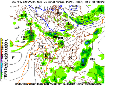
Saturday evening...

>> Saturday, July 08, 2006

Beautiful evening out there...get out and enjoy.

Sunday looks quite nice with mainly mid 80s for highs and continued lower than average humidity. The latest GFS MOS numbers have come in....it is down to 57 for a low tonight in Charlotte. I have 59 going in my official forecast. For your information, 57 is the record low in CLT for tomorrow.

Somebody asked below what the dewpoint is. As I am typing this, Charlotte's dewpoint is 58 degrees. So, that means that if the actual air temperature was 58 degrees, the relative humidity would be 100%, and the air would be saturated. The dewpoint is the temperature at which that layer of the atmosphere would be saturated.

Everyone have a great night. Have a great Sunday, and enjoy the weather! God bless...

Read more...

This is July???

Beautiful this morning. I saw lots of temps in the 50s to start the day...including Concord at 55! It looks like the Charlotte airport bottomed out at 59....1 degree above the record. Many mountain locations dipped into the 40s again this morning. Grandfather Mountain (the summit) got down to 47.

Just great weather. It will be great all day with comfortable humidity values, lots of sun, and highs in the mid 80s. Get out and enjoy...you don't get treats like this in July very much!

Looks like not much will occur regarding the possible low pressure forming off of the southeast coast. It will probably bring some rain to portions of the New England states through tomorrow, but for the Carolinas, not many problems aside from some showers near the Outer Banks.

Enjoy the weather today! Do something outdoors. I will be in the weather office this afternoon....my on-air shift starts at 5:01pm. Looks like a nice and quiet day in the office.

Read more...

Gorgeous Weather...

>> Friday, July 07, 2006

Cooler and drier air is taking hold over our region. That cooler and drier air will make for a beautiful day today and tomorrow.

By the way, it is a rather chilly start up in the mountains this morning with Boone and Grandfather Mountain down in the 40s!

Look for low to mid 80s today, and with dewpoints in the 50s, and maybe even 40s at times, it will be extremely pleasant out there.

I mentioned here in this space early Wednesday morning that I thought Charlotte might challenge the record low of 58 Saturday morning. Well, I am now forecasting a low of 58 tonight, so I think Charlotte has a good shot at typing or even breaking the record low for tomorrow.

Tomorrow looks great with lots of sun, mid 80s for highs, and continued low humidity values.

Trouble from the tropics???
It is really quite amazing that most computer models continue to indicate a low pressure forming somewhere off of the southeast coast this weekend. I only say it is amazing because so far, there are no real signs of that occurring.

Our own in-house computer model develops a low pressure east of Jacksonville early tomorrow morning, then moves that low inland near Wilmington and keeps it spinning over eastern North Carolina through Sunday. If that solution verifies, wholesale changes would have to be made to our Sunday forecast around here. If that solution occurs, we would be looking at rain chances and lots of clouds Sunday. The NAM is also indicating rain chances here Sunday. Here is the surface map valid 8pm Sunday from the 6z run of the NAM today...


However, at the moment, I am just mentioning partly cloudy skies and dry weather continuing Sunday. But, this forecast might have to be amended as we go through time and see whether or not that low pressure will develop.

Elsewhere, the tropics are very quiet.

Later next work week, we get back to more typical summertime stuff around here. Look for muggy conditions to return with the chance for mainly afternoon showers and storms Tuesday through Friday.

Read more...

Thursday afternoon...

>> Thursday, July 06, 2006

Rain continues to exit the area. Looks like most spots in the viewing area received between 0.5" and 1.5" of rain with this event.

Nice, dry airmass getting set to move in. As I am typing this, the dewpoint in Knoxville is down to 59 and Boone at 57.

Heat and humidity are probably my least favorite weather elements, so I am going to love the weather tomorrow and the weekend. It will be beautiful with highs in the mid 80s and very low humidity values...considering it is July.

I mentioned yesterday that I thought some communities had a shot of dipping into the upper 50s for a low this weekend. I am sticking to that even though model data continues to indicate lower 60s. I still think some backyards have a shot of dipping into the upper 50s, probably Saturday morning. Interesting to note that a few places in Wisconsin dropped down to 37 degrees this morning....pretty incredible for July 6!

Looks like we will be back in a much more muggy pattern again as next work week progresses. Along with that will come the chances for mainly afternoon showers and storms.

Tropics...
It seems several computer models want to develop some sort of low pressure off of the Georgia or South Carolina coast, then lift if northeastward just off of the Atlantic Seaboard. Seems plausible, but I don't think it is much to get too excited about just yet.

About the only other thing I can think of to watch for in the tropics is the Gulf of Mexico. The same frontal boundary that is moving through here will stall out in the northern Gulf. Often times, if conditions are right, a weak tropical system can from from a decaying frontal boundary like that. So, possibly the Gulf might be something to watch this weekend.

Read more...

Good Morning!

>> Wednesday, July 05, 2006

In the early-morning on-air seat this morning. Only wound up getting about 1 hour of sleep last night. We all headed to watch one of the fireworks displays last night...had a great time. However, traffic afterward was horrible....took an hour and a half to get home.

At any rate, I have the coffee hooked up to me through an I.V., and I am ready to go.

Looks like we will see a pretty good number of scattered showers and storms this afternoon. A little more in the way of upper level dynamics are in play today, and I do think some severe weather problems will occur in some spots. Be aware of that. Large hail and damaging winds will be the main threats. Also, vivid lightning and locally heavy rains will likely be a problem.

Overnight, a cold front pushes in. With the loss of daytime heating, the intensity of the storms will likely decrease. However, I think the coverage of showers and storms will increase. Flash flooding could very well be a problem tonight.

Look for lots of showers and storms tomorrow morning, with diminishing chances for showers and storms as the day progresses.

The stage is still set for a delightful Friday and weekend. Highs will be in the 80s with lots of sun and comfortable humidity values.

I am forecasting a low Friday morning of 61 and Saturday morning of 60. The record low for Charlotte Friday is 55 and Saturday is 58. That Saturday low could be pretty close. I tell you....I for one would not complain if we managed to dip into the upper 50s on a July morning! Here is the 0z GFS surface map for 8am Saturday morning. Notice the big high pressure sitting right overhead....Excellent radiational cooling conditions should be in place.


Tropics...
Upper air low is spinning near southern Florida this morning. That system has at least some shot at development as it crawls toward the Gulf over the next few days. Elsewhere, all is quiet.

I hope everyone had a great Fourth! I will finish up my shift today, then head home for a healthy nap!

Read more...

Independence Day

>> Tuesday, July 04, 2006

Happy Fourth of July to everyone!


Nowadays, it seems like I have errands and the like piled up to do on my off days, and that is the case again this week. So, that is the reason for no post yesterday.

For the Fourth, it will be....hot as a firecracker...I know, tired joke, but one I felt I had to use anyway. Any storms today should be few and far between.

Still looks like very good shower and storm chances Thursday as a cold front slips through here. Some of those storms could certainly pack a punch.

And behind that front, a rather delightful airmass for July will move in here for the weekend. Look for abundant sunshine this weekend with highs only in the 80s and comfortable humidity values.

Independence Day...
Take some time today and reflect on how blessed we are to live in this great country. As a people, sometimes it is rather easy to get caught up in our day to day difficulties and the differences that exist between us in this country. However, the bottom line is we are incredibly fortunate to have the opportunity to live and work here. Take some time and remember that today.

Spending some time with family today. My wife's parents are visiting with us. We will do some griling later today, then go and watch some fireworks this evening. It will be a quick turn-around for me in the morning...I am on the early morning on-air shift tomorrow....will hit the air at 5am.

Have a safe and happy Fourth....God bless.....

Read more...

Severe storms...

>> Sunday, July 02, 2006

A couple of severe storms developed late this afternoon. Severe thunderstorm warnings were issued for Gaston and eastern Mecklenburg counties.

Damage reports I have heard of:

  • Golf ball sized hail fell an covered the ground in Stallings in Union county
  • Tree down on Hickory Grove Road in northeast Gaston county
  • Nickel size hail and trees down in Mint Hill
  • Quarter size hail near intersection of I-485 and Hwy 74
  • 1.5" of rain just east of Matthews

Thank you so much to those of you that called in an emailed in storm reports. That is incredibly helpful to us in times of severe weather. All of the technology in the world can not beat a set of eyes in terms of telling you what is going on.

This final report from Paula Johnson near Matthews....
"The final rain total in my yard was 1.8 inches. Lot of small branches & leaves down all over the yard. A large branch from a sweet gum tree, heavy with leaves and green gum balls came down - not uncommon for that kind of tree in my yard - think it just got too heavy with the rain."

Things will be quiet overnight. The earlier storms were fired off by an outflow boundary from earlier storms up in the mountains.

Everyone have a great night. I will post from time to time over the next couple of days.

Read more...

  © Blogger templates Shiny by Ourblogtemplates.com 2008

Back to TOP