Storms Firing Now

>> Saturday, July 22, 2006

It looks like we have now reached the time where storms are going to fire rather rapidly around our area. Look for a good amount of showers and storms for the next couple of hours. Some storms will likely be severe from time to time. Keep up to date!

Read more...

Delayed, but not denied....

After handing the reigns off to Tara early this morning, my head hit the pillow at home about 4:30am. Back in the saddle again this afternoon. Tara and I will hand off in the wee hours again if things are active tonight.

So far, so good today. However, a cold front is moving our way from the west, and I think we will begin to see showers and storms light up over eastern Tennessee and western North Carolina over the next few hours. Those showers and storms will move in here through this evening and probably through a good chunk of the night as well.

Some of those storms could be strong to severe. The SPC has maintained a slight risk of severe weather for our region tonight.

Maybe things will remain quiet, but I have a feeling we will be burning the midnight oil again tonight....

Read more...

Early Morning Update...

Severe weather threat looks low through the early morning hours. It does look like much of the viewing area will have some rain with embedded storms at times, but significant severe weather looks unlikely. Pretty impressive that many places are still in the lower 80s at the 2am hour though...

Read more...

Severe Thunderstorm Watch

>> Friday, July 21, 2006

MCS rolling our way from Kentucky and Tennessee this evening. Because of that, the SPC has put out a Severe Thunderstorm Watch for the Carolina mountains, and the watch extends as far east as Cleveland and Lincoln counties. The watch officially expires at 4am.

The storms are on a weakening trend as they approach the mountains, and I am skeptical that any severe weather threat will make it into much of the viewing area overnight. Regardless, I will be in the weather office keeping watch until any potential danger passes.

Read more...

Unsettled weather ahead...

Storms are firing in the mountains as I am typing this. Like yesterday, these storms will gradually send outflow boundaries out that should fire off some showers and storms in our viewing area through this evening. A couple of storms could be strong to severe.


Saturday looks like a pretty active day here in the weather office. Cold front gradually approaching us from the west....nice 500mb trough down into the lower Mississippi Valley....and a jet streak moving into the northeast U.S. The wind fields are not as strong as we would see with a Spring-time storm system, but fairly impressive instability levels should be able to overcome that and provide us with a pretty decent chance at severe weather. I think quite a few warnings will likely be required as the day progresses Saturday, and the showers and storms could continue on into the overnight hours of Sunday morning. We will watch it all very carefully.

In the tropics, Beryl (I am finished debating the pronunciation of this thing!) is becoming an extra-tropical system, and the NHC has issued its final advisory for it.

There is a tropical wave way in the eastern Atlantic that bears watching, but it is still days away from even the islands of the Caribbean. Interestingly enough, it is battling dry and and dust from Africa, and so far that is hindering development.

T-ball...
Our t-ball game yesterday evening was cancelled due to nearby thunderstorms. Some disappointed kids for sure. My daughter fell asleep on the way over to the game, then woke up when we got back home after being turned around at the fields. Took us a while to explain that we actually did try to go to the game. Se we had some good family time playing ball at home yesterday evening instead....

Read more...

Some Quick Friday Morning Notes

With Jeff now off and enjoying some well-deserved vacation time, I will slide into the evening shift today. They folks in Raleigh will handle the midday package, but I will be in by early afternoon and will handle any issues that arise this afternoon and evening.

Today, set-up looks to favor scattered storms this afternoon and early evening. Some storms could be locally strong to severe, with damaging winds and small hail the primary threats.

However, the set-up for tomorrow is looking more and more favorbale for possibly more widespread severe weather. In fact, here is the SPC's outlook for Saturday...
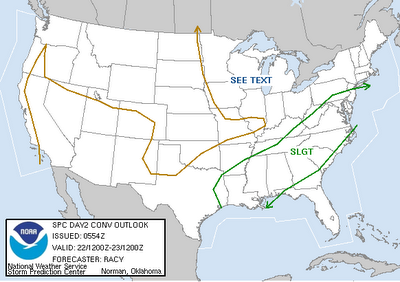

Damaging winds will probably be the main threat tomorrow, but it is possible a couple of supercell storms could form as we head through the afternoon and into the evening.

As always, we will be right there on the air with you to walk you through the storms. Stay tunes to News 14 Carolina for all of the latest today and tomorrow.

Beryl scraped eastern Massachusettes this morning and is now heading to the Canadian maritimes. It is becoming a non-tropical low pressure area. Elsewhere, the tropics remain quiet.

Have a good day. I will be in the weather office this afternoon and will have some blog posts for you as we head through the day and weekend.

Stay tuned...

Read more...

Afternoon Update...

>> Thursday, July 20, 2006

Boundary dropping in here from the mountains looks to fire a good number of showers and storms off this afternoon and evening. Some could be strong to severe....stay with News 14 for details....

Read more...

Thursday Afternoon

First off, I questioned yesterday whether anyone actually knew how to pronounce "Beryl"....This was at the bottom of the 11pm forecast discussion from the NHC...I found it funny.

"REGARDING THE PRONUNCIATION OF BERYL...A REVIEW OF SEVERAL DICTIONARIES SHOWS THAT BOTH BER'-IL AND BURL ARE ACCEPTED PRONUNCIATIONS...AND IN FACT THE NATIONAL WEATHER SERVICE DIRECTIVE SPECIFIES THE FORMER...TWO SYLLABLE...PRONUNCIATION. THE ONLY BERYL I PERSONALLY KNOW ALSO PRONOUNCES IT BER'-IL. WE APOLOGIZE FOR ANY CONFUSION."

So there ya go....nobody knows....

Regarding Beryl, the system will either make landfall, or come very close to making landfall, on the Cape of Massachusettes tonight into early tomorrow. However, this is not a huge deal....some squally weather and several inches of rain from eastern Long Island up through eastern Massachuesettes, but that should be about it. After Beryl, the tropics look quiet for a few days.

Afternoon cumulus field was slower to go up today than yesterday, so I think all in all, few showers and storms than yesterday. Granted, I do expect isolated showers and storms (and some of the storms could be quite strong), but the overall coverage shouldn't be that great. Highs will be in the low to mid 90s.

Cold front stalls out overhead this weekend giving us very good chances for showers and storms both Saturday and Sunday. Front then washes out, and we are back to more typical stuff next work week.

Read more...

Wednesday Afternoon...

>> Wednesday, July 19, 2006

Well, it looks like the weather will not allow me to put on a long post this afternoon due to some active storms.

Severe thunderstorm ongoing in southwestern Richmond County, and new storms are trying to develop farther west. Could be a couple of more warnings this afternoon. Be aware, some hail, potentially damaging winds, tremendous lightning, and heavy rainfall can be expected if you find yourself under one of these thunderstorms.

Outside of the storms, lots of heat and humidity with highs in the mid to even upper 90s today. I know I saw our temperature here at the station make it up to 97 degrees.

Shower and storm chances greatly increase by the weekend as a frontal boundary approaches from the north and stalls out through at least Monday. Each day Saturday through Monday should feature good chances for showers and storms, and highs will back off into the upper 80s.

Beryl...
By the way, does anybody know how to pronounce the name of this storm?? Tough to get a clear-cut pronunciation for it...

I think we will see some intensification of Beryl as we head through the next 24 hours or so, but this really should only be a nuisance storm, possibly making a landfall somewhere over the New England states in a passing fashion. However, rip tides will be an issue along the Carolina coast for the next couple of days.

Read more...

Quick Morning Post....

Putting the final touches on my shows for today...hit the air at 11:01....

Hot already today....up to 86 already the the CLT airport at 10am...ouch. Going to be a hot one...maybe the hottest day of the year????

Beryl still churning out in the western Atlantic....much more on that a bit later.

Gotta get ready to go on the air...will post a full post later today...

Read more...

Good Tuesday Morning...

>> Tuesday, July 18, 2006

Lots of activities going on during my off days this week, so not much time to post. But, a couple of items...

  • Lots of heat today once again. Look for mid to even upper 90s for highs.
  • Model sata now pretty consistent that the heat will hold through the rest of the work week with mid to even upper 90s for highs.
  • Possible tropical development off of the Carolina coast. Hurricane Hunters will head into the area today if necessary. System is showing a nice flare-up of thunderstorm activity this morning. We will see if it can sustain it. It will slowly head northeastward over the next 4-5 days.
  • Current temperature atop Grandfather Mountain is a pleasant 64 degrees.....low this morning was 59. Very nice!

Everyone have a great day. Another busy day today, so I don't know if another post will be coming or not. Will be back in the weather office tomorrow mornning and will hit the air at 11:01....

Read more...

Sunday Evening....

>> Sunday, July 16, 2006

A welcome quiet evening after all of the action Saturday. No complaints here....

Things look hot and dry this work week. Tuesday looks to be the hottest day with mid to upper 90s area-wide. I still think some spots could challenge 100....

Stalled frontal boundary off of the Carolina coast has had some flare-ups of showers and storms with it at times. Often times, set-ups like that can spawn some sort of tropical system. It remains to be seen whether or not that will occur this time, but it bears watching since the overall upper air pattern is not too hostile for development, and the warm Gulf Stream runs through that area.

Heading into my weekend here....will probably post a couple of times Monday or Tuesday.

Everyone have a great week......

Read more...

  © Blogger templates Shiny by Ourblogtemplates.com 2008

Back to TOP