Winter Ideas for Charlotte and the Surrounding Areas

>> Saturday, November 18, 2006

A couple of primary factors have gone into my winter ideas for this year. The first of which is the El Nino that is occurring this winter.

I firmly believe this will be a winter where the El Nino is at its strongest in early winter with a steady weakening of the El Nino as we progress to late winter. I think most of the winter will be spent in the "weak" El Nino category, with only a very brief time, if any at all, spend in the "moderate" category.

Another fascet of this year's El Nino is the matter of where the above-normal temperatures will be located in the Pacific. Here is the current (as of 11/18/06, as I am composing this outlook) sea surface temperature anomoly.


The shades of green, orange, yellow, and red are the above-average sea surface temperatures. Right now, the warmest surface water temps in the Pacific are rather close to the South American coast. However, if you look at the water temps at depth through the Pacific, and not just at the surface, the water temps are cooling beneath that very warm water at the surface in the eastern Pacific. So, I feel we will probably see that warm surface water in the eastern Pacific cool with time over the next couple of months. Again, looking at the water temps at depth, the temperatures beneath the surface are warming between about 140W and 180W, and I think as winter progresses the central Pacific will become the "dominant" area of warmer waters.

So, what does that mean? Generally speaking, in El Nino winters where the warmest waters are located just off of the South American coast, our area tends to have a milder than average winter due to a strong Pacific jet racing across the U.S. In El Nino winters where the warmest waters are located out in the central Pacific, the Pacific jet is still there, but it is much more favorable for shots of cold air to make it down into the eastern U.S. Keep that in mind.

Another fascet I feel is critical to our winter outlook is the NAO. That is the North Atlantic Oscillation, and it is a comparison of the barometric pressures between the subpolar low and the Azores high. I will just leave the description at that...if you have any questions about the NAO, I can get into it more deeply. At any rate, back to the forecast....

Since late summer, the NAO has generally been in the negative category. See the chart below.


Negative NAO's typically are favorable for colder and more snowy weather patterns during the winter months over the eastern U.S. I see no substantial reason for the NAO to switch around to a primarily positive phase through the winter, so I think much of the winter should be spent with a neutral to negative NAO, especially toward January and February.

There are some obviously plenty of other factors involved in my forecast that I won't bore you with in this space right now, but I have highlighted two of the factors that I feel will be very important this winter.

So, with that said, here is my actual forecast for this winter for the Piedmont of North Carolina. I feel the "core" of this winter will occur during the months of January and February, and probably some of March as well. December will probably feature some wide temperature swings, but I think the month as a whole will average near or slightly above average for temperatures. My forecast for CLT for December temps is +0.5 degrees.

I have gone back and forth with which month I think will be the coldest of the winter between January and February. For the forecast, I have decided on February. I think both months will have continued swings in temperatures, but overall, I think both months will be below average as the El Nino relaxes somewhat. So, my temp forecast for January is -1.5 degrees and February is -2.0 degrees.

As for precipitation, I think this will be a winter that features a good amount of southern branch storm systems rolling through the eastern U.S. I think the chances are good that the Charlotte area will see above average snowfall for the season. In fact, I expect the region to see several ice and/or snow threats as winter unfolds, especially during the months of January and February.

So, here is the recap.

Monthly temperature deviation from average:

December: +0.5
January: -1.5
February: -2.0

Read more...

North Carolina Tornadoes

>> Thursday, November 16, 2006

The NWS has finished some storn surveys around the area. Check out the link below:

http://kamala.cod.edu/offs/KGSP/0611162307.nous42.html

Looks like a few places in Gaston, Lincoln, and Iredell counties saw tornadoes last night.

Early next week continues to look "interesting." I will try to post more as time allows. Also, I will post my brief forecast for the upcoming winter for Charlotte sometime over the next week or so.

Terrible situation over in eastern North Carolina in the Riegelwood area. My prayers are with those folks. Read some preliminary information from the WIlmington, NC NWS at the link below...

http://kamala.cod.edu/offs/KILM/0611162348.nous42.html

Read more...

Storm Recap

Well, severe weather raked through the viewing area last night. Wind damage was reported in several counties, and some power outages have occurred. In fact, my oldest daughter has had school cancelled today due to power being out at her school.

It looks like areas a little west of Charlotte saw the worst of the damage in the Charlotte News 14 Carolina viewing area. Locations in Gaston and Lincoln counties reported wind damage. Tornado warnings were even issued for Yadkin and Guilford counties in the Triad viewing area.

I have always been fascinated watching thunderstorms roll through. I was afraid of night-time thunderstorms as a child, but that fear turned to respect and awe as I grew older. Being a broadcast meteorologist, you hardly ever get to actually watch storms as they move through. You are always on the air during those times, trying to keep folks safe as severe weather and storms are occurring. Don't get me wrong, I love severe weather coverage, and that is by far the most important part of our job. But, I will say it was a bit of a treat for me last night. As the line of storms rolled through our area, it was nice to be able to just sit and watch the beauty of night-time thunderstorms.

Read more...

Tornado Watch

>> Wednesday, November 15, 2006

The atmosphere around our viewing area has rapidly destabilized as we have gone through the past couple of hours. At the Gastonia airport, the temperature jumped from 60 to 67 degrees and the dewpoint jumped from 53 to 62 degrees in 1 hour's time!

A tornado watch is in effect for Cleveland, Gaston, Mecklenburg, Union, Cabarrus, and York counties. That watch is officially set to expire at 5am Thursday morning.

Look for a strong line of storms to blow through the area over the next 3 to 4 hours. Damaging winds are a distinct possibility, and a couple of isolated tornadoes will be possible as well. For those of you that are meteorologically-inclined, this is a situation where we have tremendous amounts of shear involved, so LEWPS and bow echos will be likely from time to time.

Stay weather-alert throughhout the night tonight. Jeff will continue to have continuing information for you on News 14 Carolina.

Read more...

Wintry Weather??

>> Monday, November 13, 2006

I am continuing on my leave this week. Again, many thanks to all of the good folks at News 14 Carolina for covering for me and pulling some extra shifts. My family and I greatly appreciate it!

Some interesting happenings in the weather ahead. First of all, a dynamic storm system wraps up over the Lower Mississippi Valley late Wednesday and lifts to the Great Lakes Thursday. The dynamics with this storm system will be very supportive of severe weather Wednesday in parts of Louisiana, Mississippi, Alabama, the Florida panhandle, and probably parts of Tennessee, Kentucky, and Georgia. The thermodynamics are a bit of a question mark, meaning the depth and quality of available instability remains to be seen. However, I think parts of that region are in for a healthy round of thunderstorms with lots of wind and probably some tornadoes.

As that system rolls through here, we will see rain and probably some storms. Some of our storms could even be strong to severe in the Wednesday night-Thursday morning time-frame. Keep it tuned to News 14 Carolina for all of the latest weather information.

Behind that storm system, chillier weather moves in for Thursday and Friday. I think flurries will fly Thursday up in the North Carolina mountains, and I think some mountain locations could see a bit of accumulating snow. Our weekend weather looks rather benign.

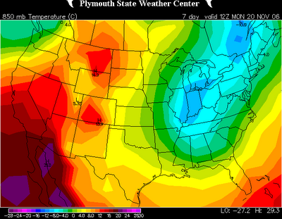
Interesting model developments for next Monday and Tuesday. For several runs now, some models have been developing a closed 500mb low somewhere near the Carolinas. From time to time the GFS has had this scenario, and now the 12z European is on board. Below is the 850mb relative humidity then the 850mb temperature charts for 7am Monday morning.

It sure looks like precipitation is falling around the Carolinas, and across parts of the area, the airmass is marginally cold enough to support something of the wintry variety. Looking from the European model site (the data I can view beyond Day 7 on the European model is limited), the 500mb low closes off and is sitting right over the Carolinas Tuesday morning. This would indicate very cold air aloft. So, what does this mean???

Well, first off, the chances of this exact solution verifying are slim. And, even in this exact scenario, the lower levels of the atmosphere outside of the mountains and foothills are likely too warm for snow. But, it sure is interesting, and this appears to be our first little winter weather potential of the season to watch. Again, this is probably nothing major at all, but it peaks my interest.

I also should mention that next Monday and Tuesday will likely be downright cold for November. I think 40s for highs are a good possibility, and it could wind up being lower 40s at best on one or both days. Stay tuned!

Read more...

  © Blogger templates Shiny by Ourblogtemplates.com 2008

Back to TOP