Wintry Weather??
>> Monday, November 13, 2006
I am continuing on my leave this week. Again, many thanks to all of the good folks at News 14 Carolina for covering for me and pulling some extra shifts. My family and I greatly appreciate it!
Some interesting happenings in the weather ahead. First of all, a dynamic storm system wraps up over the Lower Mississippi Valley late Wednesday and lifts to the Great Lakes Thursday. The dynamics with this storm system will be very supportive of severe weather Wednesday in parts of Louisiana, Mississippi, Alabama, the Florida panhandle, and probably parts of Tennessee, Kentucky, and Georgia. The thermodynamics are a bit of a question mark, meaning the depth and quality of available instability remains to be seen. However, I think parts of that region are in for a healthy round of thunderstorms with lots of wind and probably some tornadoes.
As that system rolls through here, we will see rain and probably some storms. Some of our storms could even be strong to severe in the Wednesday night-Thursday morning time-frame. Keep it tuned to News 14 Carolina for all of the latest weather information.
Behind that storm system, chillier weather moves in for Thursday and Friday. I think flurries will fly Thursday up in the North Carolina mountains, and I think some mountain locations could see a bit of accumulating snow. Our weekend weather looks rather benign.
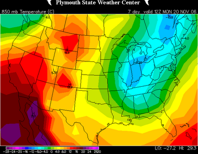
Interesting model developments for next Monday and Tuesday. For several runs now, some models have been developing a closed 500mb low somewhere near the Carolinas. From time to time the GFS has had this scenario, and now the 12z European is on board. Below is the 850mb relative humidity then the 850mb temperature charts for 7am Monday morning.

It sure looks like precipitation is falling around the Carolinas, and across parts of the area, the airmass is marginally cold enough to support something of the wintry variety. Looking from the European model site (the data I can view beyond Day 7 on the European model is limited), the 500mb low closes off and is sitting right over the Carolinas Tuesday morning. This would indicate very cold air aloft. So, what does this mean???
Well, first off, the chances of this exact solution verifying are slim. And, even in this exact scenario, the lower levels of the atmosphere outside of the mountains and foothills are likely too warm for snow. But, it sure is interesting, and this appears to be our first little winter weather potential of the season to watch. Again, this is probably nothing major at all, but it peaks my interest.
I also should mention that next Monday and Tuesday will likely be downright cold for November. I think 40s for highs are a good possibility, and it could wind up being lower 40s at best on one or both days. Stay tuned!

0 comments:
Post a Comment