Well...

>> Saturday, June 24, 2006

Well, it turned out to be a very quiet day in the weather office.....I, for one, am not complaining.

There will be the chance for a shower or storm from time to time tonight, but I don't expect anything widespread tonight. The latest Stormcast run still shows a slug of tropical moisture pushing through tomorrow. So, I still think the idea of fairly widespread areas of rain and storms for Sunday is a good one. And, we look to do it again Monday.

The low near the Bahamas is running out of time to develop. However, it has about 24 hours or so left over water, and it could develop into a tropical depression. Either way it will spread lots of rain up our way over the next couple of days.

Flash flooding could become a problem over the next few days with general rain amounts between 1 and 4 inches, with some locally higher amounts possible.

Read more...

Not Much Going On Yet

Well, I am in the process of building my graphics for my on-air block which begins at 5pm. So far, all we have seen out there is a couple of isolated showers and storms. It is looking more and more that we will not see a very large coverage of showers and storms this evening and tonight. The forecast package I am putting together right now mentions "a chance for some showers and storms" tonight...but I think we are looking at a scattered type situation.

However, our in-house computer modelling is really hitting home the idea that we will see a slug of tropical moisture push in here from the southeast tomorrow. I think the areas of rain and storms will be pretty widespread tomorrow.

More details later in the evening...

Read more...

Unsettled weather continues...

Lots of debris clouds this morning left over from all of yesterday's rain and storms. However, we should see some pretty good intervals of sunshine work in as the morning and early afternoon hours progress.

The atmosphere was worked over very well yesterday by the rain and thunderstorms, but as we get the sunshine in here, we should heat the atmosphere back up and destabilize it again. The stage should be set for another round of areas of rain and storms this afternoon and evening.

Just like yesterday, rain amounts could be heavy, mainly due to the slow-moving nature of the rain and storms. A flash flood watch is in effect for the entire viewing area. The atmospheric profile should be a little less favorable for severe weather, but with that said, small hail and gusty winds could still be a problem. Also, the storms today will likely once again be prolific lightning producers.

So, keep it tuned to News 14 Carolina, and we will be there with you, walking you through the storms.

Having some family time this morning, then I will be into work this afternoon and evening. Have a great weekend!

Read more...

Wow...

>> Friday, June 23, 2006

Active afternoon and evening of weather. Very slow-moving thunderstorms moved across basically every square inch of the viewing area. Most folks saw a good, soaking rain, and some places had some flash flooding issues. This was primarily due to the very slow movement of the areas of rain and storms.

Quite a few severe thunderstorm warnings were issued. I began continuous coverage at around 3:30, and Jeff and I tag-teamed it until 5:00 non-stop. I called it a day at roughly 6pm(remember I signed on the air today at 11am) while Jeff has continued live weather hits all evening. That is the true beauty of News 14 Carolina. We have the ability to be there with you, walking you through the storms as they happen. We consider that our primary responsibility, and it is an honor to do so.

This storm report came in from 1 mile northwest of Woodleaf in Rowan county:
"TREES AND POWERLINES DOWN...BLOCKING ROAD ON COOL SPRINGS RD AT HART RD. POWER POLES ALSO REPORTED BLOWN DOWN. (GSP)"

Things should settle down tonight, but it looks like things will set themselves up for another active weather day tomorrow afternoon and evening. Stay tuned...

Time to spend a little time with the family, head to bed, and get ready for another potentially active day tomorrow. Have a safe night....

Read more...

Storms about to fire...

Visible satellite imagery clearly shows where yesterday's outflow boundary stalled out, and that is where storms will first fire over the next couple of hours. The boundary is draped across Rowan, Cabarrus, Mecklenberg, Gaston, and southern Cleveland counties.

Read more...

Active Storms Likely This Afternoon and Evening

Definitely another hot and steamy day out there. Dewpoints are hanging around in the low 70s and temps are approaching (and should get into) the 90s. Very uncomfortable day.

However, the stage is set for scattered storms to fire as we get deeper into the afternoon hours. We have tremendous amount of low level moisture in place, and it is just a matter of heating the atmosphere up to the necessary temperature (convective temperature) before we see the showers and storms fire.

The upper level winds are still not very strong today, but they are a bit stronger than yesterday. So, I expect most storm motions today to be 5-15mph. Locally heavy rains a tremendous lightning will probably again be a problem.

Tropical Moisture...
As the stationary front remains stalled just to our west, we will begin to have a deep fetch of tropical moisture brought in here on a southeasterly low level flow. This looks to set up a pattern of numerous areas of showers and storms Sunday, Monday, Tuesday, and maybe even Wednesday as well. Some copious rainfall amounts could fall during that period, so some flooding issues could arise.

Tropical Depression forming???
The system east of the Bahamas that we have been discussing for days is getting better organized. A recon plane will likely get sent into the system tomorrow. The system has a decent chance of becoming a tropical depression within the next 24-48 hours. Lets discuss some of the computer model data for this potential tropical system...

  • The GFS takes the system in the general direction of Florida.
  • The Canadian model generally takes the system toward north Florida or Georgia.
  • The Navy NOGAPS model takes the system toward north Florida of Georgia.
  • And the WRF model appears to take the system to the Georgia or South Carolina coast.
  • The European model takes the system into Florida.
  • The UKMET model takes the system to near Jacksonville.

All in all, almost every model meanders the system somewhere over the southeast for a couple of days after it moves inland. I think this should only enhance our ran and storm chances early next week. Keep checking back for updates....

T-ball update...
T-ball went very well last night. It was a lot of fun, and the kids all did great. Neat experience.

Read more...

Friday Morning!

Good morning...hazy sunshine and muggy conditions this morning. The atmospheric set-up is a little different today though, and the chances for scattered showers and storms look pretty good this afternoon and evening. Like we saw in the mountains and foothills (and northern Cleveland county) yesterday, some of the storms could grow severe.

Will hit the air at 11:01 this morning. I will have a full blog post later today.

Have a great morning, and I will talk to you in a while....

Read more...

Cleveland county severe...

>> Thursday, June 22, 2006

Those storms over the mountains and foothills have gradually edged into western parts of the area. The storms could be locally strong to severe over the next couple of hours. Northern Cleveland is under one of those storms as I am typing this.

Read more...

Storms...

Interesting to watch the storms over western North Carolina this afternoon. They are barely moving this afternoon, and because of that, flash flooding is now a concern in the areas underneath of those storms. Rain is falling at a rate of 2-3 inches per hour with some of the storms.

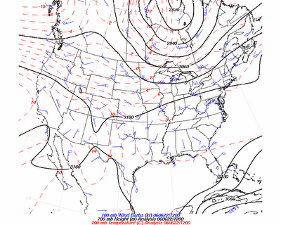
Why are the storms barely moving?? On a typical summertime day, the 700mb flow is what determines storm motion. Here is the 700mb analysis from this morning...


Notice how there is basically no winds at 700mb overhead today. Therefore, the storms develop, then eventually collapse back on top of themselves because there are no upper level winds in place.

Read more...

Full Thursday afternoon post

First of all, Mecklenberg officially reached Code Red ozone status for today. You know we are getting into ozone season as Jeff and I have fired up the air purifier here in the weather office that converts O3 to O2. You can keep tabs of the latest count by clicking here...

http://maps.co.mecklenburg.nc.us/website/airquality/

The forecast for tomorrow is Code Orange.

Aside from the ozone, the heat is oppresive today. Here are some of the 3pm temps...

Shelby: 97
Salisbury: 97
Gastonia: 95
Charlotte airport: 95

Current heat index values are in the upper 90s to low 100s area-wide. Please use caution outdoors today.

The weather is a-changin' ....
Changes are on the way as a frontal boundary eases our way over the next couple of days. There are some active thunderstorms in the mountains and foothills this afternoon, and it looks like that zone of shower and storm chances will ease into the viewing area beginning tomorrow. So, I expect scattered showers and storms tomorrow and Saturday, mainly during the afternoon and evening hours.

By Sunday, tropical moisture will be involved, and it still looks like Sunday through Wednesday will feature numerous showers and storms. The exact details are still in question, but some generous amounts of rain could fall in that time period around the Carolinas.

Tropics...
The area of disturbed weather northeast of the Bahamas is getting better organized. It could become a tropical system over the next day or two. However, regardless of whether or not it becomes a tropical system, it will still increase shower and storm chances over the southeast US late in the weekend and early next week.

Speaking of rainfall, even though most sites are above average for the month of June, most of that rain came at one time....Alberto's rains. So, the soil has substantually dried out in many spots. And, our friends in Cleveland county largely missed out on that rainfall. So, we are still very much so in need of rain across most of western and central North Carolina. Now it is a little different story up in Raleigh where 5-10 inches of rain fell with Alberto.

T-ball...
I mentioned back on Monday that I am one of the coach's for Jayden's t-ball team. This evening, we have our first game. It should be a lot of fun. We have the video camera charged and ready to go and the folding chair packed for my wife and youngest daughter. Of course, their first game has to occur on the hottest day so far this year.....but that's OK, doesn't hurt to shed a few pounds steering kids around the bases....

Read more...

Good Morning!

Lots of heat on the way today....take it easy out there.

Also, Code Red Ozone day for today in the Charlotte area. Please do the best you can to help out with the ground level ozone problem.

Putting together the forecast package right now...will hit the air at 11:01. I will have a full discussion posted a little later on.

By the way, my Father's Day present was a tad late in arriving, but it came in yesterday. It is a travel coffee mug with a picture of my kids on there....excellent present!

Read more...

Wednesday Afternoon Full Post

>> Wednesday, June 21, 2006

The 1pm observations are showing that most places in the area are already in the lower 90s. The forecast for mid 90s looks good. An isolated storm is possible, but most places still look to stay dry.

Air quality is a problem today with Code Orange days for both the Charlotte and Raleigh areas. Be aware of that and take steps to help out with the air quality situation.

Interesting to watch the weather up around Raleigh. This morning it looked like the coverage of storms up that way would be isolated at best, but it appears the outflow boundary from overnight storms up in The Ohio Valley sparked the showers and storms up there. Check out the visible satellite imagery by clicking below.

http://weather.cod.edu/satellite/1km/Carolinas/Carolinas12.gif

The heat will remain with us tomorrow and Friday. Scattered showers and storms will be possible Friday, with an increasing coverage of showers and storms Saturday and Sunday. The heat will back down as the chances for showers and storms increases. Look for mainly 80s for highs Saturday through Wednesday.

Everything still looks good for numerous showers and storms Monday through Wednesday around here. Here is a look at the 12z GFS for 8pm Tuesday.


A frontal boundary looks to stall just west of here, and that will provide us with very good chances for showers and storms during that time period. If all goes well, we could see some good drought relief from this set-up...keep your fingers crossed.

Tropics...

Still watching the area northeast of the Bahamas. The chances for significant development of that system are somewhat small, but it bears watching. Regardless, I think the most likely scenario is the system gells with the frontal boundary mentioned above and enhances the rainfall across the southeast. This could wind up being a flooding situation somewhere over the southeast, and we will watch it closely.

Time to eat some lunch. Everybody stay cool today...


Read more...

Wednesday early afternoon...

Heat is cranking in the Charlotte News 14 viewing area. Some spots already in the low 90s. Looks like mid 90s for most with heat index values approaching or exceeding 100 this afternoon.

Up in Raleigh, some showers and storms have developed early this afternoon. Looks like those were sparked by the outflow from overnight showers and storms over the Ohio Valley. Some of those storms could contain some small hail or gusty winds as well as heavy rainfall where they do develop this afternoon.

Interesting feature northeast of the Bahamas this afternoon. More on that later...

I am still in the middle of my live block...lots going on today, so I will not be able to post until a little later this afternoon. Check back later for the full afternoon discussion and post.

Thanks so much for stopping by. I really appreciate that people enjoy seeing what I have to say. Thanks a lot!

Read more...

Hot Stuff

>> Tuesday, June 20, 2006

The heat continues to build this week. As I am typing this, most places in North Carolina (outside of the mountains) are in the low to mid 90s.


Speaking of the mountains, the current temperature of 66.5 degrees at the summit of Grandfather Mountains sure sounds nice right about now! Check out the link below...

http://www.aws.com/aws_2001/asp/obsforecast.asp?id=LINVL

Monday and Tuesday constitute my weekend, so that is why there has not been much in the way of posting here over the past 2 days. However, I am back in the saddle again tomorrow...my on-air shift begins at 11:00am.

Everyone have a great evening. God bless...

Read more...

Good afternoon!

>> Monday, June 19, 2006

Well, I am happy to report the vehicle issues mentioned below have been resolved. We are back and running well now.

I have not had a chance to look at weather information so far today, so I can't add a lot of insights to that right now. But the heat is certainly going to build this week, and you need to be careful not to over-exert yourself outdoors later this week.

I hope you all have a great evening. I am off to t-ball practice....I am one of the coaches for Jayden's (our 3 year-old) team. She is lobbying hard for a pre-practice stop at McDonald's....we shall see.

Read more...

Car troubles....

>> Sunday, June 18, 2006

Saturday night, I had finished up my work here at News 14 Carolina for the night, and I was beginning the roughly 30-minute drive home. About 10 minutes into the drive, I feel something is wrong with the car. I can immediately tell what it is....a flat left front tire. Thankfully, I was at a good place where I could stop quickly, and there were some street lights that allowed me to see what was going on. This thing was flat....not going flat...not kinda flat....we are talking flopping flat.

So, there I was. A situation almost all of us have been in at one time or another. I am sure it was a rather amusing sight to see me trying my best to change the tire without completely messing up the clothes I was wearing. Well, got the spare tire on, and wouldn't you know it, it is extremely low on air. I guage that there is enough air in there that I can safely and slowly drive home, and then the car could sit there until I could fix the problem Monday (my off day). That's the end of that part of the story.

My plan for driving into work today was to drive in the family vehicle (minivan). Well, we got back home from church and lunch, and I got out and left it running. My plan was to go inside, grab my stuff for work, and then leave. Well, when I get back out of the house, the van is no longer running. I get in, try to crank......nothing......it won't start. Here is the deal with that...

Our driveway goes rather steeply downhill. The gas intake is located in the rear of the gas tank, so even though we had 4 or 5 gallons of gas, the incline was enough to make the gas run away from the intake. So, there the van sits.

So, I hop back over in the car, drive to a gas station to fill the spare up with air, then make the drive in to work. So, tomorrow will be spent fixing the tire problem for the car as well as getting enough gas in the van to get it going again. Not a big disaster by any means, but I thought I would share the story with you.

At any rate, I hope everyone had a great Father's Day. I will make a post from time to time tomorrow or Tuesday, then I will be back in my normal Wednesday routine with full blog posts resuming then. Have a great Monday, and God bless...

Read more...

Sunday Evening Full Post...

As I mentioned over on the News 14 Carolina main weather site, we had some high clouds stream overhead earlier in the day today, and primarily due to that, most highs only reached the mid 80s, as opposed to the upper 80s I forecasted last night.

There are lots of storms popping off to our west from parts of the Ohio Valley back into the Lower Mississippi Valley, but we have another dry night on tap tonight with low to mid 60s for lows.


Clouds will increase by later Monday as a weakening frontal boundary approaches from the northwest. Some computer model data indicates western parts of the area, say Cleveland and Gaston counties, could see a shower or storm Monday afternoon. The best chances for a few showers and storms will be Monday evening.

I think the big weather story around our region this week will be the building heat. I have 93 for a high in Charlotte Wednesday and Thursday, but some spots could certainly be warmer than that if all pans out as it looks like it will right now. Below is the 850mb chart for Wednesday evening off of the 12z GFS run. The warmer the temps are at 850mb, in general the warmer temps are on the ground. And when you start seeing 850mb temps up around 20 degrees Celcius around here, it should really feel like summer.


It looks like a trough could set up off to our north by next weekend. If that does indeed take place, we could find ourselves in a pattern featuring numerous showers and storms, especially in the afternoon and evening. Below is the surface map for Saturday evening off of the 12z GFS.

The tropics are very quiet. There are no organized tropical waves out there, so no development is expected. I took a quick scan of the tropical computer models, and I see no signs of development occurring in the near future. However, most models are indicating some lowering pressures overall in the Caribbean Sea later next week, so that might be the next area to watch for signs of development down the road a bit.

In the middle of my live block right now. A little later this evening I will tell you about some vehicle troubles I have had....

Read more...

Happy Father's Day

Happy Father's Day to everyone out there!

All is quiet in the weather department this morning. Today will again feature lots of sun and warm temps...I think mainly upper 80s for highs.

I will be back in the weather office this afternoon and have a full blog post online late today. Like yesterday, my on-air block starts at 5:01.

Be sure and check back later as I tell you my experience as I am heading home from work last night.

Off to eat breakfast, then head to church.....

Read more...

  © Blogger templates Shiny by Ourblogtemplates.com 2008

Back to TOP