Good Morning!
>> Wednesday, July 05, 2006
In the early-morning on-air seat this morning. Only wound up getting about 1 hour of sleep last night. We all headed to watch one of the fireworks displays last night...had a great time. However, traffic afterward was horrible....took an hour and a half to get home.
At any rate, I have the coffee hooked up to me through an I.V., and I am ready to go.
Looks like we will see a pretty good number of scattered showers and storms this afternoon. A little more in the way of upper level dynamics are in play today, and I do think some severe weather problems will occur in some spots. Be aware of that. Large hail and damaging winds will be the main threats. Also, vivid lightning and locally heavy rains will likely be a problem.
Overnight, a cold front pushes in. With the loss of daytime heating, the intensity of the storms will likely decrease. However, I think the coverage of showers and storms will increase. Flash flooding could very well be a problem tonight.
Look for lots of showers and storms tomorrow morning, with diminishing chances for showers and storms as the day progresses.
The stage is still set for a delightful Friday and weekend. Highs will be in the 80s with lots of sun and comfortable humidity values.
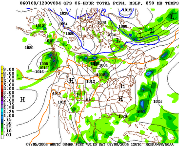
I am forecasting a low Friday morning of 61 and Saturday morning of 60. The record low for Charlotte Friday is 55 and Saturday is 58. That Saturday low could be pretty close. I tell you....I for one would not complain if we managed to dip into the upper 50s on a July morning! Here is the 0z GFS surface map for 8am Saturday morning. Notice the big high pressure sitting right overhead....Excellent radiational cooling conditions should be in place.
Tropics...
Upper air low is spinning near southern Florida this morning. That system has at least some shot at development as it crawls toward the Gulf over the next few days. Elsewhere, all is quiet.
I hope everyone had a great Fourth! I will finish up my shift today, then head home for a healthy nap!

0 comments:
Post a Comment