Friday Evening Post
>> Friday, December 15, 2006
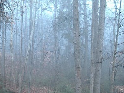
 This is a shot taken of the woods out behind our house this morning. As you can see, the fog was quite dense. I know when I was driving to take Jayden (my oldest daughter) to preschool this morning, the visibility was less than a tenth of a mile....kinda felt like taking your life into your own hands when pulling out onto roads!
Speaking of preschool, today was the Birthday Party for Jesus for Jayden's class. All of the parents were invited, and it was neat to be there and see how things are going in school. My wife and I already seem to get very few details about how school is going from Jayden...I can only imagine how it will be as she gets older! The teachers do a great job with those kids, and it was a fun experience this morning.
As far as the weather is concerned, unseasonably warm weather will continue through Monday. But, as I have been mentioning for quite some time, we will transition back to a colder weather pattern later next week.
It seems the picture next week is becoming a bit clearer....however, in general, many of the computer models are still a convoluted mess. It appears a cold front will slip through, likely in dry fashion, Tuesday. Behind that front, highs look to mainly be in the 50s for the rest of the work week.
A 500mb low pressure area will eject out of the Southwest later next week. This type of scenario is one that computer models typically handle very poorly. The 0z run of the GFS tracked the 500mb low right over the Carolinas late next week. So, due to the very cold air aloft associated with the upper low, that run of the GFS featured a shot at some wintry precip for us as the low moved overhead.
However, subsequent GFS runs have shifted the track of the low farther north, and I think that farther north track is likely the correct one. The European model agrees with the farther north track as well. So, at this point, I am forecasting some showers later Thursday into Friday. There will likely be some wintry weather underneath that upper low, but at this point I think that will up over the Ohio Valley and not here.
Temps for Christmas should be relatively close to average for that time of year (50s for highs, 30s for lows). However, I like the idea of a big trough amplification around the 26th or 27th that could send a shot of cold air in here.
Long story short, I think this overly warm weather pattern ends next week, and the rest of the month will feature near or below average temps in general.

2 comments:
Hey matt, whats your opinion on the 0z 12/16 canadian?
Not sure which aspect of the 0z Canadian you are referring to. It is definitly farther north with the 500mb low track next week (and at first glance through just waking up eyes this morning, so is the 0z European). And, it does show a nice Gulf low approachin us next weekend with a definite CAD signal shown on the model. Interesting run for sure, but I will have to delve into the rest of the model suite later today....
Post a Comment