
Snow tonight...

>> Tuesday, February 03, 2009


A new edition of the Carolina Weather Video is posted above. Please see the video for lots of good information on our little snow event tonight.

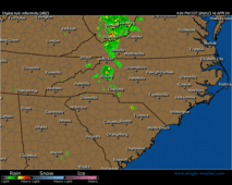
Generally speaking, I still like the chances of the state seeing convective snow showers tonight. Tons of energy aloft will be moving through. The only real negative to snow chances....and it is a significant negative....is limited low level moisture.

I have some general accumulation areas outlined in the video. Generally speaking, I will say anyone in the state could see a dusting tonight. Areas from the Triad over toward the Triangle I will include in a general 1-3" category, while some localized spots, likely a bit north of I-40, could pick up 2-5." The best shot of higher accumulations will be where a couple of heavier snow bands set themselves up, and it is impossible to tell in advance in this type of set up where that will occur.

Please understand that these will be snow showers. That means they will occur in a hit and miss fashion. Some folks will wind up with no snow at all tonight, while 1 or 2 counties over could see a decent accumulation.

Please keep in mind, this is not your typical snow event. If the airmass takes longer than anticipated to moisten, snow amounts will be lower.

The NWS has hoisted a Winter Weather Advisory for the Triad and Triangle regions, with a Winter Storm Warning for the Virginia border counties north of RDU.

Temperatures will plunge into the 20s tonight for lows, so any accumulation of snow will likely include roadways as well. This will likely be a very powdery snow, but I do anticipate some road problems in some spots tonight and tomorrow morning.

Keep it tuned to News 14 Carolina on television for all of the latest weather information. I will be on the air in the Triad market tomorrow morning. We will be full steam ahead with live crews bringing you up to the date information. In the Triad, News 14 Carolina is the only local news station with the ability to show you live DOT cameras.

If anything significantly changes, I will post some new info here on the blog. Otherwise, we will see how thing unfold tonight.

Read more...

Snow chances....and COLD

**Our News 14 in-house network connectivity is down this morning, so I am doing this from a remote laptop here at work. No new video this morning as the video cutting software is all on the computer with no connectivity this morning.**

Rain did indeed change to snow in the Triad into the Triangle this morning....even a few flakes in the Charlotte region. Most accumulations were on grassy surfaces and rooftops. So, some folks are getting to wake up to a whitened scene this morning in the Triad. Temps are below freezing now in many spots, and black ice is forming on area roadways, especially in the Triad. Please use extreme caution this morning. Some Triad school system are operating on a delay this morning....please see News 14 Carolina on television for details.

We will see sunshine this morning, but clouds roll right back in this afternoon as our next potent upper level disturbance approaches from the northwest. I have no changes to my earlier ideas. I think the Piedmont will see hit and miss snow showers this evening and tonight. Some snow will likely accumulate, especially the farther NORTH you live in the state. Snow ratios will be very high, and temps will be plenty cold. Some spots could pick up an inch or two of snow tonight, especially along and north of I-40. However, a dusting is possible anywhere tonight, and some pockets could pick up a bit more than that elsewhere as well.

This cold air that is settling in means business. Highs tomorrow and Thursday will only be in the 30s with lows in the 20s tonight, teens Thursday morning, and 20s Friday morning. However, a nice warm-up is coming as we head into the weekend, and I expect highs Saturday and Sunday to be in the 60s.

Overall, next week looks mild and fairly quiet. However, I think the weather pattern for the second half of this month could be exciting. I am working on these ideas, but we could see a mild storm system swing through somewhere between the 11th and 15th, and after that storm system passes, we could head into a colder and stormier pattern through the end of the month. Don't hold me to it yet though...these ideas are in progress.

Read more...

One more mild day...

>> Monday, February 02, 2009

**No new edition of the Carolina Weather Video this morning...I left my mic at home this morning!**

We will see one more day of mild weather today with highs in the upper 50s to around 60 in the Piedmont.

A cold front is approaching from the west, and this is what we call an 'anafront'....in other words, most of the precip will actually fall after the cold front passes. So, that this means for the Piedmont is the chance of some rain showers from late this afternoon into this evening, ending as some snow in some spots. Any snow should be short in duration, and due to that, any snow accumulation should be confined to rooftops and grassy areas.

Tomorrow will be much colder with highs in the low to mid 40s, and then a potent upper level disturbance will move through tomorrow evening. That disturbance will spread some snow showers through the Carolinas, but exactly where will see the best chance of snow remains an unknown this morning. Due to the very cold nature of the airmass by tomorrow night, the snow ratios will be quite high, so it would not take much precip to get some snow accumulation in spots. So, somebody in the Piedmont could wind up with at least a bit of snow on the ground by Wednesday morning, but like I said, where that might be remains a big question mark.

Up in the mountains, I think this will be a nice snow event. Snow will begin there by tomorrow afternoon, and periodic snow showers will then occur through Wednesday night. Total snow amounts could exceed 6" in spots, and the most favored of locations might see close to 10."

Lots of cold air is heading our way. We will likely see many Piedmont locations in the 30s for highs Wednesday and/or Thursday with some lows in the teens Thursday morning. Temps will moderate by the weekend.

Speaking of the weekend, we had a good one, but a busy one. My oldest daughter had a cheer leading game Saturday morning, then we had a birthday party to head to Saturday afternoon. It was my turn to teach Sunday School yesterday morning, we had some after-church functions yesterday afternoon, and then finally we went over to some friends house to watch the Super Bowl last night.

I told them going in that I would leave at halftime so as to get home and wind down for bed. However, we were all having a great time, and we would up staying until the game was over. Obviously, short night of sleep for me, but we had a great time.

I will keep you updated on the forecast....although, I nice nap will definitely occur today!

Read more...

  © Blogger templates Shiny by Ourblogtemplates.com 2008

Back to TOP