
Good morning!
>> Saturday, November 25, 2006
It is fairly chilly out there as I am typing this this morning. Many locations had lows well down into the 30s. However, we will see highs close to 70 degrees today and tomorrow, so get out and enjoy.
If you have travel plans today or tomorrow, no real weather problems to worry about over the eastern U.S. However, another strong storm system will plow into the Pacific northwest tonight and tomorrow, and if your travel plans take you to that part of the country, you certainly could run into some delays there.
The big weather story this week will be a brutal surge of arctic air spreading across the country. That arctic air will arrive here Thursday night and Friday.
It is interesting to note that there have been some indications from time to time that another coastal low pressure area will try to develop around Friday. And why not?....each of the past couple of big troughs have managed to produce coastal low pressure areas. But I will admit that there are not as many model clues pointing to that scenario as there was the last time around. But, there is a difference with this weekend's possible coastal storm.....genuine arctic air will be in place across the eastern U.S.
So, while the jury is still out on whether another coastal system will form the end of this week, if it does form, it would likely produce primarily wintry weather over the Eastern Seaboard. The GFS has gone back and forth as to whether or not to develop a coastal low. The 6z run that just rolled in does indeed develop one. Look at the image below...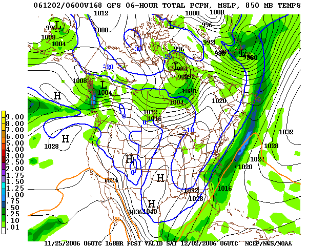
If that solution were correct, that would be snow falling Friday night in much of the Carolinas.
So, what to make of this....Well, it is simply too early for me to make a call. I do think there is a chance that this coastal low will develop, but at this point, it is just that....a chance. We shall see.
One thing is a near-certainty....much colder air will flow in here Friday and next weekend. I think 40s at best for highs with lows well down into the 20s. And, if we can get a night next weekend with a clear sky and light winds, I think some spots could possibly dip into the teens! Brrr....


