12z has it too

>> Thursday, August 17, 2006

12z GFS also develops a tropical system that it bring close to the eastern US by the first couple of days of September. Here is the surface chart for 8am Sept. 2...


Will be interesting to watch....

Will be out of town for a few days here. I will try to post from time to time if time allows.....

Read more...

Beautiful day!

Comfortable levels of humidity out there today as dewpoints have dropped into the upper 50s to lower 60s on northeasterly winds. Very nice stuff! Enjoy....

We should stay dry with relatively lower levels of humidity tomorrow and Saturday before our next cold front slowly moves across the region Sunday through Tuesday. Those days look to feature scattered showers and storms.

Tropics...
I tell you...like I mentioned yesterday, the low off of the SC coast sure looks like a tropical depression. The National Hurricane Center makes those official determinations, and they have not declared it a TD. However, it is sure close to it. It is probably semantics anyway because upper level winds are becoming increasingly hostile over the system. Due to that, significant development is unlikely.

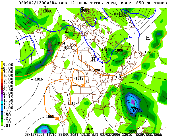
For two runs in a row now the GFS develops a tropical system in the Atlantic and tracks it toward the US east coast during the first couple of days of September. In fact, check this out from the 6z run today...this is valid 2am September 1...


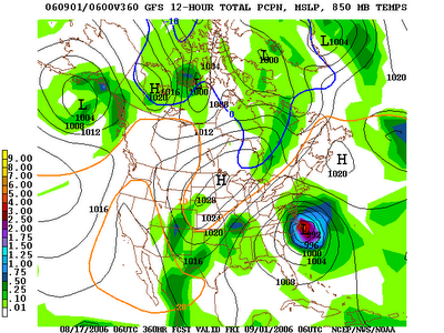
Now, this is out in la-la land for the computer models, so specifics are not to be looked at. However, I think this is indicative that by the beginning of September we will be entering a more active time in the tropics. Stay tuned...

Read more...

I Stand Corrected....

>> Wednesday, August 16, 2006

Per the NHC at 4:05pm...

REPORTS FROM AN AIR FORCE RECONNAISSANCE PLANE INDICATE THAT THEAREA OF LOW PRESSURE CENTERED ABOUT 150 MILES SOUTHEAST OF THECOASTS OF NORTH AND SOUTH CAROLINA IS PRODUCING MAXIMUM SUSTAINEDSURFACE WINDS OF ABOUT 25 MILES PER HOUR IN A FEW ISOLATEDTHUNDERSTORMS. THIS SYSTEM HAS NOT YET BECOME A TROPICALDEPRESSION AND ADVISORIES ARE NOT BEING INITIATED AT THIS TIME. HOWEVER...THE POTENTIAL STILL EXISTS FOR THIS SYSTEM TO BECOME ATROPICAL DEPRESSION AT ANY TIME DURING THE NEXT DAY OR SO...BEFOREUPPER-LEVEL WINDS BECOME MORE UNFAVORABLE FOR DEVELOPMENT ONTHURSDAY.

Read more...

Tropical Depression???

Based on radar and satellite data here in the weather office, the system off of the Carolina coast sure looks like it has attained at least tropical depression status. We will see how the NHC handles it this afternoon based on recon data.....

http://www.ssd.noaa.gov/goes/flt/t2/loop-vis.html

Read more...

Rain

Lots of rain and storms last night in parts of the area. Radar estimates parts of Meck county saw upwards of 4 inches...thus, the flash flooding problems.

Front is sagging southward and in general rain is coming to an end around our area.

Recon plane is heading into the low pressure off of the South Carolina coast this afternoon. The system looks a little healthier at this time, so it will be interesting to see what they find....

Read more...

Beautiful Stuff

>> Sunday, August 13, 2006

It doesn't get much better in mid-August than the weather we had today. Just great with lots of sun, highs in the low to mid 80s, and very pleasant humidity values.

A bit warmer and muggier tomorrow, but still not bad considering the time of year.

Cold front gradually moves through Tuesday and Wednesday....scattered shower and storm chances both of those days. It still looks like the front will make it south of the area, so I am keeping the forecast primarily dry Thursday through next weekend.

Tropics...
Two areas to discuss this evening. First, a tropical wave in the Caribbean Sea. It is not as healthy looking now as it was this morning, but still an area that bears watching for signs of development.

Secondly, most models continue to indicate that some sort of tropical low will develop along the stalled front off of the southeast coast. And, it looks like whatever forms could theoretically make a run at the Southeast coast beforepossibly getting turned out to sea. But it is way to early for those types of specifics....we don't even have a well-defined low pressure area yet!

Check out this link...this is the 12z run of the GFDL from today....we will certainly keep watching....

http://bricker.met.psu.edu/~arnottj/cgi-bin/gfdltc2.cgi?time=2006081312-invest93l&field=Sea+Level+Pressure&hour=Animation

Read more...

  © Blogger templates Shiny by Ourblogtemplates.com 2008

Back to TOP