Good morning!

>> Saturday, November 25, 2006

It is fairly chilly out there as I am typing this this morning. Many locations had lows well down into the 30s. However, we will see highs close to 70 degrees today and tomorrow, so get out and enjoy.

If you have travel plans today or tomorrow, no real weather problems to worry about over the eastern U.S. However, another strong storm system will plow into the Pacific northwest tonight and tomorrow, and if your travel plans take you to that part of the country, you certainly could run into some delays there.

The big weather story this week will be a brutal surge of arctic air spreading across the country. That arctic air will arrive here Thursday night and Friday.

It is interesting to note that there have been some indications from time to time that another coastal low pressure area will try to develop around Friday. And why not?....each of the past couple of big troughs have managed to produce coastal low pressure areas. But I will admit that there are not as many model clues pointing to that scenario as there was the last time around. But, there is a difference with this weekend's possible coastal storm.....genuine arctic air will be in place across the eastern U.S.

So, while the jury is still out on whether another coastal system will form the end of this week, if it does form, it would likely produce primarily wintry weather over the Eastern Seaboard. The GFS has gone back and forth as to whether or not to develop a coastal low. The 6z run that just rolled in does indeed develop one. Look at the image below...


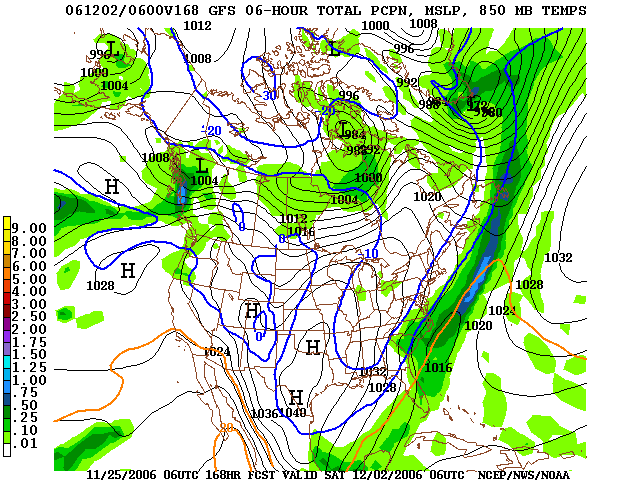
If that solution were correct, that would be snow falling Friday night in much of the Carolinas.

So, what to make of this....Well, it is simply too early for me to make a call. I do think there is a chance that this coastal low will develop, but at this point, it is just that....a chance. We shall see.

One thing is a near-certainty....much colder air will flow in here Friday and next weekend. I think 40s at best for highs with lows well down into the 20s. And, if we can get a night next weekend with a clear sky and light winds, I think some spots could possibly dip into the teens! Brrr....

Read more...

Happy Thanksgiving!

>> Thursday, November 23, 2006

I am covering all 3 markets for the midday shift today, so not much time to post. However, a couple of quick notes.

  • Clearing has taken place and beautiful weather is taking hold.
  • Sunshine with milder temps the rule through the weekend....probably some 70 degree high temps by Sunday or Monday.
  • Mild and docile weather continues into mid-week next week.
  • Cold front moves through next Thursday with some showers associated with it.
  • Big blast of cold air moves in by next Friday and next weekend. That shot of cold air will probably deliver the coldest low temperatures so far this season sometime NEXT weekend.
Everyone have a great Thanksgiving. Enjoy time with your family. And let's all be thankful for all of the blessing in our lives. God bless....

Read more...

Lots of sleet and snow reports...

>> Tuesday, November 21, 2006

Lots of sleet and snow reports are coming in from around our viewing area. It seems like every county that has seen the precip begin has seen at least a brief period of a mix of sleet and snow with the rain. This wintry mix will likely continue through much of the afternoon before the upper levels of the atmosphere warm up some tonight. Surface temps remain above freezing, so no accumulations or travel problems are expected, outside of wet roads. For those of us who love winter weather, enjoy today....I know I am!

Read more...

Wintry Morning

Amazing stuff off to our south and east this morning. Charleston, SC has actually had thundersnow, a pretty rare in its own right. But it is certainly quite a rarity in Charleston. This is apparently the earliest recorded snowfall in Charleston as well. Snow has also been reported in Fayetteville, NC. Temps all across the upper SC coast and lower NC coast are in the 30s with howling winds out of the north and northeast. Wind gusts are over 40mph.

Around the Piedmont, precip is spreading in from the east. As the precip begins this morning into early this afternoon, we will probably see some sleet or snow mixing in with light rain for a while before the atmosphere warms a bit by late afternoon. No wintry precip accumulations are expected around our area, but it sure is a wintry day. I think we will struggle to get out of the 30s in many spots, and winds will be brisk out of the north sustained at 10-25mph. Bundle up!

Read more...

Flakes in the air...

>> Monday, November 20, 2006

Asheville and Jefferson have reports some light snow at times this morning.

As the day progresses, I really think we will have a difficult time making it out of the 40s here in the Piedmont. Also, some light rain will occur from time to time, and I would not at all be surprised to see some snowflakes mix in at times. No big deal, but something neat if you do see it!

Read more...

Monday Morning Update

Models are coming into better agreement in the handling of the big upper air low this week. In short, it is looking pretty wet in the Tuesday through Thursday time frame for the Carolinas. Obviously, lots of folks will be travelling this week, and certainly there looks to be a lot of rain to deal with in the mid-week time period in the Carolinas.

This developing storm will batter coastal areas of the Carolinas with a few days of onshore flow, high surf, and lots and lots of rain. Beach erosion and flooding will likely be a problem.

It is also interesting to note that the past couple of runs of the GFS have indicated the chance that the precip begins as a period of snow and/or sleet down in South Carolina Tuesday morning. The NAM sounding are warmer, indicating all rain. But, I certainly would not be shocked if some of our friends in South Carolina saw a brief mix tomorrow morning before warmer air takes hold from the coast. Interesting to see this coming to fruition....if you scroll below to the post from last Monday, you can see I was discussing the European solution for this time period...it was indicating some wintry weather chances back then. Certainly an odd weather pattern.

Directly below this post is my Winter Outlook. Take a look and feel free to comment.

Read more...

  © Blogger templates Shiny by Ourblogtemplates.com 2008

Back to TOP