

Full Saturday Evening Post...
>> Saturday, June 17, 2006
It is a calm weather evening around here. We had the afternoon cumulus field develop as expected today, and those cumulus clouds will fade away quickly with the loss of daytime heating this evening. We will again see a clear sky tonight with lows in the low to mid 60s. There are lots of showers and storms off to our west over the Plains and Mississippi Valley, but as I mentioned, we will remain dry tonight.
For the past couple of days, our highs have been running a few degrees below most model guidance. So, I will go with the lower side of guidance for highs for our Father's Day and forecast mainly upper 80s. If you would like to see that text model data for Charlotte, click below. In a future blog post I will explain what that means....
http://www.nws.noaa.gov/cgi-bin/mos/getall.pl?sta=KCLT
It looks like some clouds will begin to spread in here by Monday afternoon in advance of a weakening cold front. After dragging my feet, I now have gone ahead and put in shower and storm chances for Tuesday. It looks like that front will make it in here to provide the necessary mechanism to get the showers and storms going.
Beyond Tuesday, there is some uncertainty as to what happens with that decaying front. Will it shift to our south?....Will it wash out overhead?? Both are possibilities, so I have left a small chance for a shower or storm in Wednesday and Thursday.
It looks like a couple of disturbances will slide in here around Friday and Saturday, so I am mentioning shower and storm chances those days.
The heat will build as the week progresses. I think we will be looking at low to mid 90s for highs around here by the second half of the work week. Check out the map below.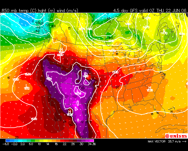
The shaded colors on that map are showing the temperature at 850mb, or about 5000 feet above the Earth's surface. In general, the warmer temperatures there are, the warmer our temperatures here on the ground are, and vice versa.
Those are some pretty warm 850mb temps nosing in here from the west....that is why I think the late-week heat is coming.
On to the tropics where there have been some flare-up of showers and storms at times with a tropical wave northeast of the Windward Islands at times today. Upper level winds are not overly favorable for development right now, but we will keep watching that area. A couple of computer models are still hinting at development coming from that region over the next few days.
Moving ahead with my on-air block as I am typing this...have a great evening, and God bless!

